
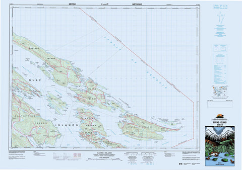
092B14 Mayne Island Canada topo map, 1:50,000 scale
092B14 Mayne Island NRCAN topographic map.
Includes UTM and GPS geographic coordinates (latitude and longitude). This 50k scale map is suitable for hiking, camping, and exploring, or you could frame it as a wall map.
Printed on-demand using high resolution, on heavy weight and acid free paper, or as an upgrade on a variety of synthetic materials.
Topos available on paper, Waterproof, Poly, or Tyvek. Usually shipping rolled, unless combined with other folded maps in one order.
- Product Number: NRCAN-092B14
- Parent Topo: TOPO-092B
- Map ID also known as: 092B14, 92B14
- Unfolded Size: Approximately 26" high by 36" wide
- Weight (paper map): ca. 55 grams
- Map Type: POD NRCAN Topographic Map
- Map Scale: 1:50,000
- Geographical region: British Columbia, Canada
Neighboring Maps:
All neighboring Canadian topo maps are available for sale online at 1:50,000 scale.
Purchase the smaller scale map covering this area: Topo-092B
Spatial coverage:
Topo map sheet 092B14 Mayne Island covers the following places:
- Annette Creek - Annette Inlet - Bedwell Harbour - Bellhouse Bay - Bennett Bay - Boat Harbour - Boat Nook - Boot Cove - Boundary Bay - Brackett Cove - Brackett Cove - Breezy Bay - Bruce Bight - Campbell Bay - Church Cove - Colston Cove - Cook Cove - Cusheon Cove - David Cove - Davidson Bay - Dinner Bay - Diver Bay - Ella Bay - Ellen Bay - Fiddlers Cove - Fulford Harbour - Gallagher Bay - Ganges Harbour - Georgeson Bay - Grimmer Bay - Hamilton Cove - Hope Bay - Horton Bay - Hyashi Cove - Irish Bay - James Bay - Kadonaga Bay - Kingfisher Cove - Little Bay - Long Harbour - Lyall Harbour - Madrona Bay - Maude Bay - Miners Bay - Montague Harbour - Murcheson Cove - Murchison Cove - Narvaez Bay - Naylor Bay - Otter Bay - Payne Bay - Percival Cove - Plumper Sound - Pollard Cove - Port Browning - Porter Bight - Reef Harbour - Richardson Bay - Selby Cove - Selby Creek - Shark Cove - Shingle Bay - Sturdies Bay - Taylor Cove - Thieves Bay - Trueworthy Bight - Veruna Bay - Village Bay - Walter Bay - Welbury Bay - Welcome Cove - Whaler Bay - Winter Cove - Chocolate Beach - Hamilton Beach - Medicine Beach - O'Reilly Beach - Saturna Beach - Ainslie Point - Aitken Point - Aldridge Point - Andaje Point - Annette Point - Athol Peninsula - Auchterlonie Point - Beaver Point - Burrill Point - Cain Peninsula - Cain Point - Campbell Point - Collinson Point - Crane Point - Croker Point - Digby Point - Dinner Point - East Point - Edith Point - Eleanor Point - Enke Point - Georgina Point - Glenthorne Point - Grainger Point - Gray Peninsula - Helen Point - James Point - Laura Point - Lord Point - Mary Anne Point - Matthews Point - McIntyre Point - Mikuni Point - Monarch Head - Mortimer Spit - Mouat Point - Murder Point - Nose Point - Paddon Point - Payne Point - Peile Point - Phillimore Point - Point Liddell - Portlock Point - Ralph Grey Point - Razor Point - Reserve Point - Rip Point - Rock Point - Salamanca Point - Saturna Point - Savage Point - Scoones Point - Scott Point - Selby Point - St. John Point - Stanley Point - Taylor Point - Tumbo Point - Twiss Point - Walker Hook - Welbury Point - Willey Point - Wilmot Head - Winstanley Point - Winter Point - Yeo Point - Active Pass - Boat Passage - Boundary Pass - Captain Passage - Georgeson Passage - Glenthorne Passage - Navy Channel - Pender Canal - Robson Channel - Strait of Georgia - Swanson Channel - Trincomali Channel - Tumbo Channel - Elliot Bluff - Grubb Bluffs - Cowichan Land District - Saltspring Island Land District - Fulford Harbour Indian Reserve 5 - Mayne Island Indian Reserve 6 - Réserve indienne Fulford Harbour 5 - Réserve indienne Mayne Island 6 - Réserve indienne Saturna Island 7 - Saturna Island Indian Reserve 7 - Acland Islands - Anniversary Island - Ballingall Islets - Belle Chain Islets - Boat Island - Boat Islet - Bright Islet - Cabbage Island - Chain Islands - Channel Islands - Charles Island - Clamshell Islet - Curlew Island - Deadman Islands - Fane Island - First Sister Island - Galiano Island - Georgeson Island - Goat Island - Gossip Island - Grace Islet - Gulf Islands - Hawkins Island - Java Islets - Julia Island - King Island - King Islets - Lion Islets - Lizard Island - Mayne Island - North Pender Island - Owl Island - Page Islet - Parker Island - Pine Island - Pine Islet - Powder Islet - Prevost Island - Red Island - Red Islets - Roe Islet - Russell Island - Saltspring Island - Samuel Island - Saturna Island - Second Sister Island - Secret Island - Skull Islet - South Pender Island - Sphinx Island - Third Sister Island - Trevor Islet - Tumbo Island - Wise Island - Blackburn Lake - Cusheon Lake - Finlay Lake - Ford Lake - Lake Stowell - Lake Weston - Magic Lake Estates Water Reservoir No. 1 - Pender Lake - Roe Lake - Ganges Harbour - Mayne Island - Bald Cone - Brown Range - Brown Ridge - Cramer Hill - Deacon Hill - Dent Hill - George Hill - Hall Hill - Heck Hill - Hope Hill - Lively Peak - Mount David - Mount Elford - Mount Fisher - Mount Galiano - Mount Hope - Mount Menzies - Mount Norman - Mount Parke - Mount Sutil - Mount Warburton Pike - Quadra Hill - Reginald Hill - Spalding Hill - Stockade Hill - Sutil Mountain - Capital Regional District - Ballingall Islets Park - Beaumont Marine Park - Beaver Point Park - Bellhouse Park - Bennett Bay Protected Area - Cabbage Island Marine Park - Gulf Islands National Park Reserve of Canada - Montague Harbour Marine Park - Montague Harbour Park - Mount Maxwell Park - Prevost Island Protected Area - Prior Centennial Park - Réserve de parc national du Canada des Îles-Gulf - Ruckle Park - South Otter Bay Protected Area - Winter Cove Marine Park - Winter Cove Park - British Columbia - Colombie-Britannique - Cusheon Creek - Finlay Brook - Fulford Creek - Ganges Creek - Greig Creek - Lyall Creek - Atkins Reef - Batt Rock - Beddis Rock - Ben Mohr Rock - Boiling Reef - Charles Rocks - Conconi Reef - Crispin Rock - Deep Ridge - Drew Rock - Enterprise Reef - Fairway Bank - Ganges Shoal - Georgina Shoals - Gossip Shoals - Governor Rock - Horda Shoal - Horda Shoals - Jackson Rock - Louisa Rock - Minx Reef - Money Maker Reef - Money Makers Rock - Parson Rock - Perry Rock - Pinnacle Rock - Rosenfeld Rock - Russell Reef - Salalikum Rock - Spire Rock - Tumbo Reef - Walker Rock - York Rocks - Beaver Point - Boundary Bay - Fulford Harbour - Galiano - Galiano Island - Ganges - Hope Bay - Hope Bay (Pender Island P.O.-B. de p.) - Lighthouse Point - Long Harbour - Mayne - Montague Harbour - Otter Bay - Pender Island - Pender Island (Hope Bay Ldg.-Déd.) - Port Washington - Saturna - Saturna Island - Sturdies Bay - Village Bay


