
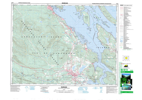
092B13 Duncan Canada topo map, 1:50,000 scale
092B13 Duncan NRCAN topographic map.
Includes UTM and GPS geographic coordinates (latitude and longitude). This 50k scale map is suitable for hiking, camping, and exploring, or you could frame it as a wall map.
Printed on-demand using high resolution, on heavy weight and acid free paper, or as an upgrade on a variety of synthetic materials.
Topos available on paper, Waterproof, Poly, or Tyvek. Usually shipping rolled, unless combined with other folded maps in one order.
- Product Number: NRCAN-092B13
- Parent Topo: TOPO-092B
- Map ID also known as: 092B13, 92B13
- Unfolded Size: Approximately 26" high by 36" wide
- Weight (paper map): ca. 55 grams
- Map Type: POD NRCAN Topographic Map
- Map Scale: 1:50,000
- Geographical region: British Columbia, Canada
Neighboring Maps:
All neighboring Canadian topo maps are available for sale online at 1:50,000 scale.
Purchase the smaller scale map covering this area: Topo-092B
Spatial coverage:
Topo map sheet 092B13 Duncan covers the following places:
- Birds Eye Cove - Booth Bay - Booth Inlet - Burgoyne Bay - Burleith Arm - Chemainus Bay - Clam Bay - Conover Cove - Cowichan Bay - Duck Bay - Evening Cove - Genoa Bay - Ladysmith Harbour - Lamalchi Bay - Maple Bay - Osborn Bay - Oyster Harbour - Preedy Harbour - Princess Cove - Retreat Cove - Sibell Bay - Southey Bay - Spotlight Cove - Stone Cutters Bay - Telegraph Harbour - Vesuvius Bay - Active Point - Arbutus Point - Augustus Point - Bare Point - Bold Bluff Point - Boulder Point - Chivers Point - Coffin Point - Crescent Point - Dock Point - Donckele Point - Erskine Point - Fernwood Point - Foster Point - Grave Point - Hospital Point - Hunter Point - Josling Point - Maxwell Point - Octopus Point - Paddy Mile Stone - Panther Point - Parminter Point - Penelakut Spit - Sansum Point - Sharpe Point - Sherard Point - Skinner Point - Slag Point - Southey Point - Walker Hook - Houstoun Passage - Sansum Narrows - Strait of Georgia - Stuart Channel - The Cut - Trincomali Channel - Duncan - Skinner Bluff - North Cowichan - Skutz Falls - Bright Land District - Chemainus Land District - Comiaken Land District - Cowichan Lake Land District - Cowichan Land District - Douglas Land District - Oyster Land District - Quamichan Land District - Sahtlam Land District - Saltspring Island Land District - Seymour Land District - Somenos Land District - Chemainus Indian Reserve 13 - Cowichan Indian Reserve 1 - Cowichan Indian Reserve 9 - Halalt Indian Reserve 2 - Halalt Island Indian Reserve 1 - Kakalatza Indian Reserve 6 - Kuper Island Indian Reserve 7 - Penelakut Island 7 - Réserve indienne Chemainus 13 - Réserve indienne Cowichan 1 - Réserve indienne Cowichan 9 - Réserve indienne Halalt 2 - Réserve indienne Halalt Island 1 - Réserve indienne Kakalatza 6 - Réserve indienne Kuper Island 7 - Réserve indienne Say-La-Quas 10 - Réserve indienne Skutz 7 - Réserve indienne Skutz 8 - Réserve indienne Squaw-Hay-One 11 - Réserve indienne Squaw-hay-one 11 - Réserve indienne Tent Island 8 - Réserve indienne Tsussie 6 - Réserve indienne Tzart-lam 5 - Say-La-Quas Indian Reserve 10 - Skutz Indian Reserve 7 - Skutz Indian Reserve 8 - Squaw-hay-one Indian Reserve 11 - Squaw-Hay-One Indian Reserve 11 - Tent Island Indian Reserve 8 - Tsussie Indian Reserve 6 - Tzart-lam Indian Reserve 5 - Burial Islet - Bute Island - Chisholm Island - Coffin Island - Dayman Island - Dunsmuir Islands - Galiano Island - Gulf Islands - Hall Island - Hudson Island - Idol Island - Île de Vancouver - Jackscrew Island - Kuper Island - Leech Island - Mainguy Island - Mowgli Island - Norway Island - Reid Island - Retreat Island - Saltspring Island - Scott Island - Secretary Islands - Shoal Islands - Tent Island - Thetis Island - Vancouver Island - Wallace Island - Willy Island - Woods Islands - Brenton Lakes - Bullocks Lake - Chemainus Lake - Coronation Lake - Crofton Lake - Davis Lagoon - Fuller Lake - Heart Lake - Holland Lake - Holyoak Lake - Lake Maxwell - Laughlin Lake - Mayo Lake - Quamichan Lake - Roberts Lake - Silver Lake - Sollys Lake - Somenos Lake - St. Mary Lake - Stocking Lake - Wake Lake - Baynes Peak - Big Sicker Mountain - Bodega Hill - Bruce Peak - Burchell Hill - Coronation Mountain - Grouse Hill - Hill 60 Ridge - Little Sicker Mountain - Maple Mountain - Moore Hill - Mount Belcher - Mount Brenton - Mount Erskine - Mount Hall - Mount Maxwell - Mount Prevost - Mount Richards - Mount Sulivan - Mount Tzouhalem - Mount Tzuhalem - Seymour Range - Seymour Ridge - Stanton Peak - Stoney Hill - Tzuhalem Mountain - Vancouver Island Mountains - Vancouver Island Ranges - Capital Regional District - Cowichan Valley Regional District - Bodega Ridge Park - Chemainus River Park - Cowichan River Park - Eves Park - Mouat Park - Mount Maxwell Park - Wallace Island Marine Park - Askew Creek - Averill Creek - Banon Creek - Bear Creek - Bings Creek - Bonsall Creek - Bush Creek - Chemainus River - Chipman Creek - Cowichan River - Currie Creek - Duck Creek - Elkington Creek - Ganges Creek - Glenora Creek - Greig Creek - Haslam Creek - Holland Creek - Holt Creek - Holyoak Creek - Humbird Creek - Inwood Creek - Josiah Creek - Kelvin Creek - Koksilah River - MacIntyre Creek - Maxwell Creek - McFadden Creek - Menzies Creek - Mill Creek - Nugget Creek - Okano Creek - Porter Creek - Quamichan Creek - Quamichan River - Richards Creek - Sharpe Creek - Silver Creek - Skutz Creek - Solly Creek - Sollys Creek - Somenos Creek - South Holland Creek - Stocking Creek - Tyee Creek - Tzouhalem Creek - Tzuhalem Creek - West Banon Creek - Whitehouse Creek - Alarm Rock - Bird Rock - Centre Reef - Cluster Rocks - Collins Shoal - Escape Reef - False Reef - Grappler Rock - Holland Bank - Hospital Rock - Indian Reef - Nares Rock - North Reef - Rocket Shoal - Sandstone Rocks - Scarrow Reef - Victoria Rock - Victoria Shoal - Ladysmith - Blaineys - Camscot - Chanlog - Charter - Chemainus - Crofthill - Crofton - Culchillum - Deerholme - Eagle Heights - Fernwood - Ganges - Genoa Bay - Hayward - Hillcrest - Koksilah - Kuper Island - Maple Bay - Mount Sicker - Musgrave - North Galiano - Osborn Bay - Paldi - Sahtlam - Sahtlam - Saltair - Somenos - Stratfords Crossing - Thetis Island - Tzouhalem - Tzuhalem - Vesuvius - Vesuvius Bay - Westholme - Wheatley - Copper Canyon - Marie Canyon


