
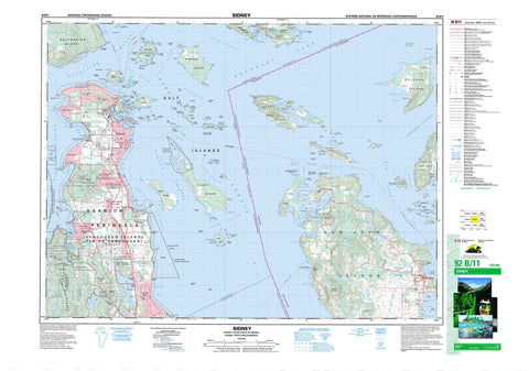
092B11 Sidney Canada topo map, 1:50,000 scale
092B11 Sidney NRCAN topographic map.
Includes UTM and GPS geographic coordinates (latitude and longitude). This 50k scale map is suitable for hiking, camping, and exploring, or you could frame it as a wall map.
Printed on-demand using high resolution, on heavy weight and acid free paper, or as an upgrade on a variety of synthetic materials.
Topos available on paper, Waterproof, Poly, or Tyvek. Usually shipping rolled, unless combined with other folded maps in one order.
- Product Number: NRCAN-092B11
- Parent Topo: TOPO-092B
- Map ID also known as: 092B11, 92B11
- Unfolded Size: Approximately 26" high by 36" wide
- Weight (paper map): ca. 55 grams
- Map Type: POD NRCAN Topographic Map
- Map Scale: 1:50,000
- Geographical region: British Columbia, Canada
Neighboring Maps:
All neighboring Canadian topo maps are available for sale online at 1:50,000 scale.
Purchase the smaller scale map covering this area: Topo-092B
Spatial coverage:
Topo map sheet 092B11 Sidney covers the following places:
- All Bay - Bazan Bay - Bedwell Harbour - Blue Heron Basin - Brentwood Bay - Bryden Bay - Butchart Cove - Camp Bay - Canned Cod Bay - Canoe Bay - ColesBay - Cordova Bay - Deep Cove - Drummond Bay - Egeria Bay - Ferguson Cove - Fulford Harbour - Hagan Bight - Lewis Bay - Patricia Bay - Peter Cove - Princess Bay - Roberts Bay - Royal Cove - Saanich Inlet - Saanichton Bay - Smokehouse Bay - Smugglers Nook - Swartz Bay - Thomson Cove - Tod Inlet - Towner Bay - Trader Bay - Tsehum Harbour - Eagle Beach - Hamsterley Beach - Island View Beach - Sayward Beach - Armstrong Point - Cape Keppel - Carney Point - Charmer Point - Coal Point - Cordova Spit - Cowichan Head - Curteis Point - Fir Cone Point - Gowlland Point - Hamley Point - Harry Point - Harvey Point - Hay Point - Henderson Point - Higgs Point - Indian Point - Isabella Point - James Spit - Kamai Point - Kamaree Point - Killer Whale Point - Kingfisher Point - Mill Point - Moses Point - Nymph Point - Parkin Point - Pelorus Point - Point Fairfax - Quadros Point - Reynard Point - Roberts Point - Saanich Peninsula - Schmidt Point - Seymour Point - Sidney Spit - Sluggett Point - Swartz Head - Teece Point - Thumb Point - Tilly Point - Tom Point - Turgoose Point - Wales Point - Wallace Point - Warrior Point - Waymond Point - Whittaker Point - Wilhelm Point - Willis Point - Wymond Point - Yarrow Point - Boundary Pass - Byers Passage - Colburne Passage - Cordova Channel - Gosse Passage - Haro Strait - Hughes Passage - Iroquois Passage - John Passage - Miners Channel - Moresby Passage - Page Passage - Prevost Passage - Satellite Channel - Shute Passage - Sidney Channel - Stranger Passage - Swanson Channel - Kanaka Bluff - Oaks Bluff - Richardson Bluff - Central Saanich - Highlands - North Saanich - Saanich - Cowichan Land District - Highland Land District - Lake Land District - North Saanich Land District - Saltspring Island Land District - South Saanich Land District - Victoria Land District - Bare Island Indian Reserve 9 - Cole Bay Indian Reserve 3 - East Saanich Indian Reserve 2 - Fulford Harbour Indian Reserve 5 - Pender Island Indian Reserve 8 - Réserve indienne Bare Island 9 - Réserve indienne Cole Bay 3 - Réserve indienne East Saanich 2 - Réserve indienne Fulford Harbour 5 - Réserve indienne Pender Island 8 - Réserve indienne Senanus Island 10 - Réserve indienne South Saanich 1 - Réserve indienne Union Bay 4 - Senanus Island Indian Reserve 10 - South Saanich Indian Reserve 1 - Union Bay Indian Reserve 4 - Arbutus Island - Blunden Islet - Brackman Island - Brethour Island - Chads Island - Clive Island - Coal Island - Comet Island - Daphne Islet - D'Arcy Island - Dock Island - Domville Island - Fernie Island - Forrest Island - Gooch Island - Goudge Island - Greig Island - Gulf Islands - Halibut Island - Harlock Islet - Hood Island - Île de Vancouver - Imrie Island - Isabella Island - James Island - Johnson Islet - Ker Island - Knapp Island - Kolb Island - Little D'Arcy Island - Little Group - Little Shell Island - Mandarte Island - Moresby Island - Musclow Islet - North Pender Island - Patrol Island - Pellow Islets - Piers Island - Portland Island - Pym Island - Reay Island - Rubly Island - Rum Island - Russell Island - Saltspring Island - Senanus Island - Sheep Island - Shell Island - Sidney Island - South Pender Island - Tortoise Island - Tortoise Islets - Vancouver Island - Young Island - Beaver Lake - Durrance Lake - Durrant Lake - Eagles Lake - Elk Lake - Fizzle Lake - Fork Lake - Greenburn Lake - Heal Lake - Killarney Lake - Pease Lake - Prospect Lake - Quarry Lake - Second Lake - Third Lake - Champ de tir Anse de Saanich - Champ de tir Détroit de Haro - Champ de tir Heals - Haro Strait Range - Heals Range - Saanich Inlet Range - Bear Hill - Cloake Hill - Cole Hill - Curtis Peak - Gowlland Range - Hermit Hill - Horth Hill - Keating Ridge - Mount Newton - Mount Tuam - Mount Wark - Mount Work - Observatory Hill - Partridge Hills - Saddle Hill - Stanford Hill - Capital Regional District - Cowichan Valley Regional District - Brentwood Bay Park - D'Arcy Island Marine Park - D'Arcy Island Park - Gowlland Tod Park - Isle-de-Lis Marine Park - John Dean Park - McDonald Park - Princess Margaret Marine Park - Refuge d'oiseaux de Shoal-Harbour - Shoal Harbour Bird Sanctuary - Sidney Spit Marine Park - Wain Park - British Columbia - Colombie-Britannique - Chalet Creek - Colquitz River - Craigflower Creek - Durrance Creek - Graham Creek - Greenburn Creek - Hagan Creek - Mill Stream - O'Donnel Creek - Pease Creek - Reay Creek - Sandhill Creek - Ten Ten Creek - Tetayut Creek - Tod Creek - Viaduct Creek - Squally Reach - Arachne Reef - Canoe Rock - Cap Rocks - Cecil Rock - Celia Reefs - Chesil Bank - Cooper Reef - Darcy Shoals - D'Arcy Shoals - Dyer Rocks - Fairway Patch - Graham Rock - Joan Rock - John Rock - Kelp Reefs - Little Zero Rock - Munroe Rock - North Cod Reef - Peck Reef - Rose Rock - Sallas Rocks - Shute Reef - South Cod Reef - Sunk Rock - Turnbull Reef - Unit Rocks - Wain Rock - White Rocks - Zero Rock - Sidney - Ardmore - Bazan Bay - Beaver Lake - Bedwell Harbour - Brentwood Bay - Cordova Bay - Deep Cove - Elk Lake - James Island - Keating - Mount Newton - Prospect Lake - Saanichton - South Pender - Swartz Bay - Tod Inlet


