
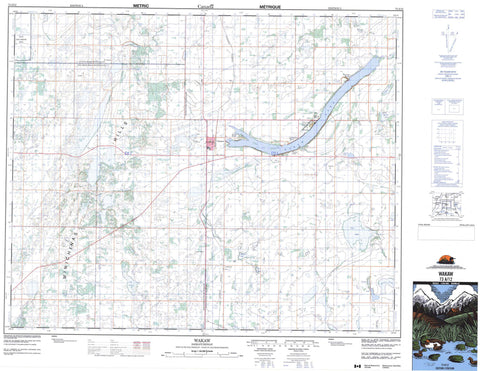
073A12 Wakaw Canada topo map, 1:50,000 scale
073A12 Wakaw NRCAN topographic map.
Includes UTM and GPS geographic coordinates (latitude and longitude). This 50k scale map is suitable for hiking, camping, and exploring, or you could frame it as a wall map.
Printed on-demand using high resolution, on heavy weight and acid free paper, or as an upgrade on a variety of synthetic materials.
Topos available on paper, Waterproof, Poly, or Tyvek. Usually shipping rolled, unless combined with other folded maps in one order.
- Product Number: NRCAN-073A12
- Parent Topo: TOPO-073A
- Map ID also known as: 073A12, 73A12
- Unfolded Size: Approximately 26" high by 36" wide
- Weight (paper map): ca. 55 grams
- Map Type: POD NRCAN Topographic Map
- Map Scale: 1:50,000
- Geographical region: Saskatchewan, Canada
Neighboring Maps:
All neighboring Canadian topo maps are available for sale online at 1:50,000 scale.
Purchase the smaller scale map covering this area: Topo-073A
Spatial coverage:
Topo map sheet 073A12 Wakaw covers the following places:
- Balone Beach - Cudsaskwa Beach - One Arrow 95-1C - One Arrow 95-1E - One Arrow 95-1H - Anna Lake - Arn Lake - Bonne Madone Lake - Constance Lake - Hoodoo Lakes - Jolly Lake - Lac Lezard - Lepine Lake - Mallard Lake - Olivier Lake - Salinaty Lake - Vier Lake - Wakaw Lake - Weixl Lake - Minichinas Hills - Fish Creek No. 402 - Hoodoo No. 401 - St. Louis No. 431 - Wakaw Lake Regional Park - Carrot River - Wakaw - Carpenter - Domremy Beach - Ens - Hoodoo - Leofnard - Lepine - Nelson Beach - Sokal - St. Julien - St. Julien - Wakaw Lake


