
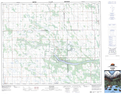
073A09 Sylvania Canada topo map, 1:50,000 scale
073A09 Sylvania NRCAN topographic map.
Includes UTM and GPS geographic coordinates (latitude and longitude). This 50k scale map is suitable for hiking, camping, and exploring, or you could frame it as a wall map.
Printed on-demand using high resolution, on heavy weight and acid free paper, or as an upgrade on a variety of synthetic materials.
Topos available on paper, Waterproof, Poly, or Tyvek. Usually shipping rolled, unless combined with other folded maps in one order.
- Product Number: NRCAN-073A09
- Parent Topo: TOPO-073A
- Map ID also known as: 073A09, 73A9, 73A09
- Unfolded Size: Approximately 26" high by 36" wide
- Weight (paper map): ca. 55 grams
- Map Type: POD NRCAN Topographic Map
- Map Scale: 1:50,000
- Geographical region: Saskatchewan, Canada
Neighboring Maps:
All neighboring Canadian topo maps are available for sale online at 1:50,000 scale.
Purchase the smaller scale map covering this area: Topo-073A
Spatial coverage:
Topo map sheet 073A09 Sylvania covers the following places:
- Lac Vert - Lac-Vert - Sylvania - Kinistin 91 - Kinistino Indian Reserve 91 - Réserve indienne Kinistino 91 - Bell's Lake - Burnett Lake - Clearwater Lake - Furgstrum Lake - Gilkey Lake - Kinistino Lake - Kipabiskau Lake - Knutson Lake - Kwatapiu Lake - Lac Vert Nord - Lawley Lake - Laytons Lake - Linstrum Lake - McArthur Lake - McPhail Lake - Mizhashk Lake - Mossdale Lake - Nikik Lake - Olsons Lake - Pentland Lake - Perch Lake - Pingwi Lake - Prost Lake - Sandy Beach Lake - Semple Lake - Spence Lake - Stewarts Lake - Wading Eagle Lake - Wascana Lake - Woods Lake - Barrier Valley No. 397 - Pleasantdale No. 398 - Star City No. 428 - Tisdale No. 427 - Kipabiskau Regional Park - Barrier River - Hanginghide Creek - Leather River - Slough Creek - Chagoness - Kipabiskau - Lightwoods - South Star - Twickenham - Wallwort - Willow Hill


