
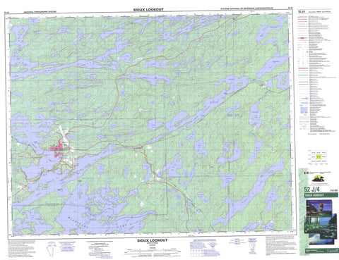
052J04 Sioux Lookout Canada topo map, 1:50,000 scale
052J04 Sioux Lookout NRCAN topographic map.
Includes UTM and GPS geographic coordinates (latitude and longitude). This 50k scale map is suitable for hiking, camping, and exploring, or you could frame it as a wall map.
Printed on-demand using high resolution, on heavy weight and acid free paper, or as an upgrade on a variety of synthetic materials.
Topos available on paper, Waterproof, Poly, or Tyvek. Usually shipping rolled, unless combined with other folded maps in one order.
- Product Number: NRCAN-052J04
- Parent Topo: TOPO-052J
- Map ID also known as: 052J04, 52J4, 52J04
- Unfolded Size: Approximately 26" high by 36" wide
- Weight (paper map): ca. 55 grams
- Map Type: POD NRCAN Topographic Map
- Map Scale: 1:50,000
- Geographical region: Ontario, Canada
Neighboring Maps:
All neighboring Canadian topo maps are available for sale online at 1:50,000 scale.
Purchase the smaller scale map covering this area: Topo-052J
Spatial coverage:
Topo map sheet 052J04 Sioux Lookout covers the following places:
- Alcona Bay - Deadman's Bay - Deception Bay - Donut Bay - East Bay - McDougall Bay - Moose Bay - Northeast Bay - Troutfish Bay - Boy Scout Point - Gordon's Sandbar - Neelands Point - Sioux Lookout Point - Frog Rapids Narrows - McDougall Falls - Windigo Falls - Benedickson - Drayton - Long Island - Maxwell Island - Neepawa Island - Powder Island - Roden Island - Starratt Islands - Abram Lake - Alkenore Lake - Allan Lake - Aubrey Lake - Batchelor Lake - Bawden Lake - Bigwood Lake - Bindo Lake - Black Lake - Bonnet Lake - Botsford Lake - Brigam Lake - Clamshell Lake - David Lake - Deception Lake - Deek Lake - Donar Lake - Drict Lake - Eastern Lake - Enira Lake - Farlinger Lake - Faulkner Lake - Fills Lake - Flavour Lake - Fore Lake - Forty Mile Lake - Forty-mile Lake - Gall Lake - Grove Lake - Hidden Lake - Jorick Lake - Kenneally Lake - Kirk Lake - Legros Lake - Limited Lake - Lincoln Lake - Little Lake - Look Lake - Lookout Lake - May Lake - Michaud Lake - Mills Lake - Minnitaki Lake - Mullen Lake - Nog Lake - Noss Lake - Out Lake - Pape Lake - Pelican Lake - Perlin Lake - Pullar Lake - Ralciv Lake - Robertson Lake - Sandel Lake - Sharron Lake - Show Lake - Snair Lake - Split Lake - Stain Lake - Star Lake - Stranger Lake - Supee Lake - Tims Lake - Tramp Lake - Ty Lake - Walton Lake - Ward Lake - Warden Lake - Yager Lake - Zarn Lake - Sioux Mountain Wilderness Area - Abram Rapids - Frog Rapids - Loon Rapids - Manitou Rapids - Bonnet Creek - Brigam Creek - Deception River - Flavour Creek - Forty Mile Creek - Gall Creek - Grove Creek - Limited Creek - Marchington River - Martin Creek - Mills Creek - Minnikau Creek - Pacific Creek - Show Creek - Tata River - Tatasiti River - McCauley's Portage - Sioux Lookout - Alcona - McDougall Mills - Rosnel - Sam Lake - Sioux Lookout - Superior Junction


