
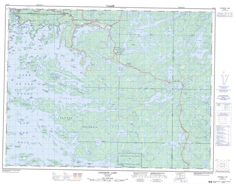
052E09 Longbow Lake Canada topo map, 1:50,000 scale
052E09 Longbow Lake NRCAN topographic map.
Includes UTM and GPS geographic coordinates (latitude and longitude). This 50k scale map is suitable for hiking, camping, and exploring, or you could frame it as a wall map.
Printed on-demand using high resolution, on heavy weight and acid free paper, or as an upgrade on a variety of synthetic materials.
Topos available on paper, Waterproof, Poly, or Tyvek. Usually shipping rolled, unless combined with other folded maps in one order.
- Product Number: NRCAN-052E09
- Parent Topo: TOPO-052E
- Map ID also known as: 052E09, 52E9, 52E09
- Unfolded Size: Approximately 26" high by 36" wide
- Weight (paper map): ca. 55 grams
- Map Type: POD NRCAN Topographic Map
- Map Scale: 1:50,000
- Geographical region: Ontario, Canada
Neighboring Maps:
All neighboring Canadian topo maps are available for sale online at 1:50,000 scale.
Purchase the smaller scale map covering this area: Topo-052E
Spatial coverage:
Topo map sheet 052E09 Longbow Lake covers the following places:
- Adams River Bay - Andrew Bay - Bald Indian Bay - Bear Bay - Beatton Bay - Bigstone Bay - Bottle Bay - East Bay - Echo Bay - Golf Course Bay - Greens Bay - Jackfish Bay - Lowry Bay - Matheson Bay - Moore Bay - P.O.W. Bay - Pine Portage Bay - Red Cliff Bay - Redwing Bay - Riches Bay - Route Bay - Smugglers Cove - St. Mary's Bay - Storm Bay - The Bowling Alley - Thunder Bay - Tomahawk Bay - Weedy Bay - Witch Bay - Yellow Girl Bay - Scotty's Beach - Bare Point - Eastern Peninsula - Finches Point - Hall's Point - Heaps Point - Heenan Point - Logans Point - Needle Point - Pine Point - Pipestone Peninsula - Pipestone Point - Treaty Point - Yellow Girl Point - Allans Narrows - Deadbroke Channel - Devils Gap - Eagle Pass - French Narrows - Moskahossi Passage - Rocky Narrows - Skull Rock Narrows - The Devil's Elbow - The Elbow - The Funnel - The Shore Island Stretch - Kenora - Devil's Rock - Code - Coyle - Desmond - Devonshire - Haycock - Jaffray - Kirkup - le May - MacQuarrie - Manross - McMeekin - Work - Kenora 38B - Kenora Indian Reserve 38B - Réserve indienne Kenora 38B - Réserve indienne Yellow Girl Bay 32B - Yellow Girl Bay 32B - Yellow Girl Bay Indian Reserve 32B - Allans Island - Allie Island - Anchor Island - Baker's Island - Bald Island - Barrier Islands - Bath Island - Bells Island - Big Island - Billygoat Island - Boulder Islands - Britannia Island - Bunn Island - Burley Island - Caldwell Island - Canniff Island - Cat Island - Chien D'Or Island - Chisholm Island - Clam Island - Cliff Island - Connor Island - Copper Island - Craig Island - Deacon's Island - Dog Island - East Allie Island - Fantasy Island - Ferrier Island - Fish Island - Fog Island - Fort Sam Island - Fraser Island - Gaherty Island - Galt Island - Goat Island - Gordon Island - Gull Island - Hades Islands - Hay Island - Houghs Island - Johnson Island - Kipling Island - Leach Island - Leisure Island - Lunny's Island - Mac Island - Manitou Island - Mather Island - Mazies Island - McEwen's Islands - Middle Island - Minnesabik Island - Nantons Island - Nepetugain Island - Nickerson Island - Oliver Island - Pewabic Island - Pickerel Island - Quarry Island - Queen Bee Island - Queer Island - Railroad Island - Ramona Island - Red Deer Island - Rideout Island - Robertson Island - Rogers Island - Sanna Island - Scotty Island - Scovil Island - Shore Island - Shragges Island - Slate Island - South Strawberry Island - Square Island - St. Helena Island - Strawberry Island - Sultana Island - Survey Island - Thompson Island - Town Island - Treaty Island - Whiteout Island - Wildcat Island - Alexandre Lake - Andy Lake - Barnes Lake - Bill Lake - Bipemaejoe Lake - Black Lake - Blindfold Lake - Bug Lake - Bull Lake - Bunion Lake - Camp Lake - Carmichael Lake - Cassadaga Lake - Chipmunk Lake - Clear Lake - Cole Lake - Corn Lake - Crusoe Lake - Desbiens Lake - Divide Lake - Dogtooth Lake - Doubtful Lake - Dryberry Lake - End Lake - Fawn Lake - Finn Lake - Flounder Lake - Forbes Lake - Gagne Lake - Gale Lake - Gelley Lake - Gibi Lake - Gold Lake - Graphic Lake - Hatchet Lake - Hilly Lake - Holger Lake - Hollow Lake - Hook Lake - Hump Lake - Ian Lake - Isabel Lake - Isabella Lake - Islet Lake - Jadakin Lake - Jimmy Lake - Kennard Lake - Kilvert Lake - Lac des Bois - Lac la Belle - Lake of the Woods - Lavender Lake - Leach Lake - Lily Lake - Little Desbiens Lake - Little Dogtooth Lake - Lodestone Lake - Lonely Lake - Longbow Lake - Loon Lake - Lunch Lake - Mac Lake - Magnet Lake - Melady Lake - Mike Lake - Monster Lake - Muskie Lake - Nabob Lake - Nelly Lake - Newman Lake - Oblong Lake - Pipe Lake - Puma Lake - Raft Lake - Rat Lake - Rattrap Lake - Riley Lake - Robinson Lake - Robinson Lake - Russ Lake - Snow Lake - Squirrel Lake - Stella Lake - Stokes Lake - Sup Lake - Tea Lake - Top Lake - Tower Lake - Ulster Lake - Viola Lake - Welsh Lakes - White Lake - Yellow Lake - McGeorge & Willingdon - Sioux Narrows - Sioux Narrows Nestor Falls - Sioux Narrows-Nestor Falls - Lake of the Woods Conservation Reserve - Rushing River Provincial Park - Adams River - Berry Creek - Berry River - Black River - Desbiens Creek - Gale Creek - Graphic Creek - Johnny Creek - Longbow Creek - Rivière Winnipeg - Rushing River - Winnipeg River - Yellow Creek - Pipestone Portage - Balancing Rock - Gardners Monument - Grace Anne Reef - Steamboat Reef - Wydemans Rock - Jaffray and Melick - Jaffray Melick - Longbow Lake


