
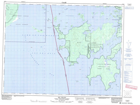
052E02 Big Island Canada topo map, 1:50,000 scale
052E02 Big Island NRCAN topographic map.
Includes UTM and GPS geographic coordinates (latitude and longitude). This 50k scale map is suitable for hiking, camping, and exploring, or you could frame it as a wall map.
Printed on-demand using high resolution, on heavy weight and acid free paper, or as an upgrade on a variety of synthetic materials.
Topos available on paper, Waterproof, Poly, or Tyvek. Usually shipping rolled, unless combined with other folded maps in one order.
- Product Number: NRCAN-052E02
- Parent Topo: TOPO-052E
- Map ID also known as: 052E02, 52E2, 52E02
- Unfolded Size: Approximately 26" high by 36" wide
- Weight (paper map): ca. 55 grams
- Map Type: POD NRCAN Topographic Map
- Map Scale: 1:50,000
- Geographical region: Ontario, Canada
Neighboring Maps:
All neighboring Canadian topo maps are available for sale online at 1:50,000 scale.
Purchase the smaller scale map covering this area: Topo-052E
Spatial coverage:
Topo map sheet 052E02 Big Island covers the following places:
- Asmus Bay - Basil Bay - Bells Harbour - Big Traverse Bay - Camp Ten Bay - Dawson Bay - Deep Bay - Little Traverse Bay - McCauley Bay - Oshie Bay - Seamo Bay - Shipwreck Bay - The Little Traverse - Verbena Bay - Aulneau Peninsula - Basil Point - Bigsby Point - Black Point - Drennan Point - Hooper Point - Northwest Point - Patty Point - Sugar Point - Basil Channel - Dawson Channel - Big Island - Big Island 31D - Big Island 31E - Big Island 31F - Big Island 37 - Big Island Indian Reserve 31D - Big Island Indian Reserve 31E - Big Island Indian Reserve 31F - Big Island Indian Reserve 37 - Lake of the Woods 31H - Lake of the Woods Indian Reserve 31H - Naongashing Indian Reserve 31A - Naongashing Indian Reserve 35A - Réserve indienne Big Island 31D - Réserve indienne Big Island 31E - Réserve indienne Big Island 31F - Réserve indienne Big Island 37 - Réserve indienne Lake of the Woods 31H - Réserve indienne Naongashing 31A - Réserve indienne Naongashing 35A - Alexandria Island - Bear Island - Big Island - Bigsby Island - Campfire Island - Cut Foot Island - Dawson Island - Dog Island - Dream Island - Fadden's Island - Ferris Island - Haas Island - Huggins Island - Hunters Island - Little Alexandria Island - Little Garden Island - Maple Islands - Nestor Island - North Haas Island - North Island - North Snake Island - Painted Rock Island - Plow Island - Pony Island - Rubber Island - Scout Island - South Haas Island - Splitrock Island - Tent Island - The Three Sisters - Tods Island - Tomahawk Island - White Rock Island - Lac des Bois - Lake of the Woods - Lake of the Woods - McCrosson and Tovell - Morson - Lake of the Woods Provincial Park - Baby Bear Reef - Foster Reef - Huggins Bar - Mama Bear Reefs - Sleeping Reefs - Windy Point Reef - Naongashing


