
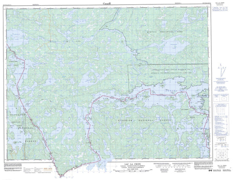
052C08 Lac La Croix Canada topo map, 1:50,000 scale
052C08 Lac La Croix NRCAN topographic map.
Includes UTM and GPS geographic coordinates (latitude and longitude). This 50k scale map is suitable for hiking, camping, and exploring, or you could frame it as a wall map.
Printed on-demand using high resolution, on heavy weight and acid free paper, or as an upgrade on a variety of synthetic materials.
Topos available on paper, Waterproof, Poly, or Tyvek. Usually shipping rolled, unless combined with other folded maps in one order.
- Product Number: NRCAN-052C08
- Parent Topo: TOPO-052C
- Map ID also known as: 052C08, 52C8, 52C08
- Unfolded Size: Approximately 26" high by 36" wide
- Weight (paper map): ca. 55 grams
- Map Type: POD NRCAN Topographic Map
- Map Scale: 1:50,000
- Geographical region: Ontario, Canada
Neighboring Maps:
All neighboring Canadian topo maps are available for sale online at 1:50,000 scale.
Purchase the smaller scale map covering this area: Topo-052C
Spatial coverage:
Topo map sheet 052C08 Lac La Croix covers the following places:
- Clearwater Bay - Martin Bay - Portage Bay - Redhorse Bay - Thompson Bay - Wilkins Bay - Dog's Point - Percy's Point - Sand Point - Tar Point - Harrison Narrows - Indian Narrows - Ivy Channel - Little Vermilion Narrows - Loon Narrows - Namakan Narrows - High Falls - Ivy Falls - Loon Falls - Myrtle Falls - Snake Falls - Rainy River - Neguaguon Lake 25D - Neguaguon Lake Indian Reserve 25D - Réserve indienne Neguaguon Lake 25D - Bear Island - Douglas Island - Eastbend Island - Eva Island - Fortyfive Island - Government Island - Hunter Island - Indian Island - Irving Island - Lonetree Island - Moosehide Island - Rabbit Island - Spool Island - Twentyfour Island - Twentysix Island - Wawa Island - Ballard Lake - Bearpelt Lake - Bill Lake - Blue Lake - Bullmoose Lake - Captain Tom Lake - Cranberry Lake - Cub Lake - David Lake - Deer Lake - Kemp Lake - Lac la Croix - Lilac Lake - Little Eva Lake - Little Vermilion Lake - Loon Lake - Marr Lake - Minnow Lake - Minnow Pond - Mudturtle Lake - Namakan Lake - Omeme Lake - Ox Lake - Pig Lake - Queer Rock Lake - Ralph Lake - Redhorse Lake - Sand Point Lake - Spring Lake - Thompson Lake - Threemile Lake - Trout Lake - Vie Lake - West Cub Lake - Wisa Lake - Wolseley Lake - Wright Lake - Lac La Croix Wilderness Area - Quetico Provincial Park - Hay Rapids - Lady Rapids - Quetico Rapids - Bearpelt Creek - Bullmoose Creek - Loon River - Moose Creek - Namakan River - Quetico River - Redhorse River - Wildgoose Creek - Beatty Portage - Hay Portage - Loon Falls Portage - Lac la Croix


