
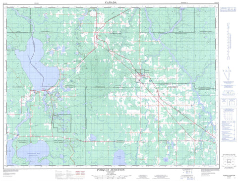
042A10 Porquis Junction Canada topo map, 1:50,000 scale
042A10 Porquis Junction NRCAN topographic map.
Includes UTM and GPS geographic coordinates (latitude and longitude). This 50k scale map is suitable for hiking, camping, and exploring, or you could frame it as a wall map.
Printed on-demand using high resolution, on heavy weight and acid free paper, or as an upgrade on a variety of synthetic materials.
Topos available on paper, Waterproof, Poly, or Tyvek. Usually shipping rolled, unless combined with other folded maps in one order.
- Product Number: NRCAN-042A10
- Parent Topo: TOPO-042A
- Map ID also known as: 042A10, 42A10
- Unfolded Size: Approximately 26" high by 36" wide
- Weight (paper map): ca. 55 grams
- Map Type: POD NRCAN Topographic Map
- Map Scale: 1:50,000
- Geographical region: Ontario, Canada
Neighboring Maps:
All neighboring Canadian topo maps are available for sale online at 1:50,000 scale.
Purchase the smaller scale map covering this area: Topo-042A
Spatial coverage:
Topo map sheet 042A10 Porquis Junction covers the following places:
- Barbers Bay - Buffalo Bay - Centre Arm - Finn Bay - North Arm - Northeast Bay - Deadman's Point - East Peninsula - North Peninsula - Timmins - Timmins-Porcupine - Twin Falls - Bond - Bowman - Calvert - Carr - Clergue - Cochrane - Cody - Currie - Dundonald - Evelyn - German - Little - Macklem - Matheson - McCart - Rickard - Stock - Taylor - Teefy - Timiskaming - Walker - Wilkie - Anniversary Island - Bald Island - Gold Island - Squaw Island - Airstrip Lake - Anderson Lake - Berthier Lake - Boy Scout Lake - Bullfrog Lake - Camp Lake - Chapman Lake - Charland Lake - Clearwater Lake - Cub Lake - Deep Lake - Deer Lake - Dundonald Lake - East Dundonald Lake - Fisher Lake - Frederick House Lake - Galloway Lake - Grassy Lake - Green Lake - Heart Lake - Homestead Lake - Horseshoe Lake - Hughes Lake - Irrigation Lake - Island Lake - Jean Lake - Keg Lake - Kettle Lake - La Viollette Lake - Lac à Booth - Lac Gauthier - Lac Lachapelle - Leece Lake - Leg of Lamb Lake - Legare Lake - Levacque Lake - Linament Lake - Linimint Lake - Lloyd Lake - Loon Lake - Low Lake - McInnis Lake - McIntosh Lake - Moose Lake - Mud Lake - Night Hawk Lake - Nighthawk Lake - Northeast Twin Lake - Otter Lake - Pexton Lake - Pine Lake - Point Lake - Reid Lake - Rice Lake - Roundelay Lake - Slab Lake - Spring Lake - Tamarack Lake - Tincan Lake - Tremblays Lake - Twin Lakes - Vader's Lake - Wabbler Lake - West Twin Lake - Wilson Lake - Black River-Matheson - Kingham - Mountjoy - Playfair - Tisdale - Whitney - Frederick House Lake Provincial Nature Reserve - Kettle Lakes Provincial Park - Shallow River Provincial Nature Reserve - Abitibi River - Black River - Driftwood River - Dundonald Creek - Frederick House River - Grindstone Creek - Hooker Creek - Little Driftwood River - Matheson Creek - Meadow Creek - Minnow Creek - Moose Creek - North Driftwood Creek - Rivière Abitibi - Rivière Watabeag - Russell Creek - Shallow River - Slim Creek - Tincan Creek - Wabbler Creek - Watabeag River - Iroquois Falls - Alert - Alexo - Anthony - Barbers Bay - Black Creek - Connaught - Fielding - Goldlands - Homer - Kelso - Kilburn - McIntosh Springs - Monteith - Night Hawk Centre - Onagon - Porquis Junction - Reynolds - Shillington - Twin Falls - Val Gagné - Watabeag - Welsh - Wings


