
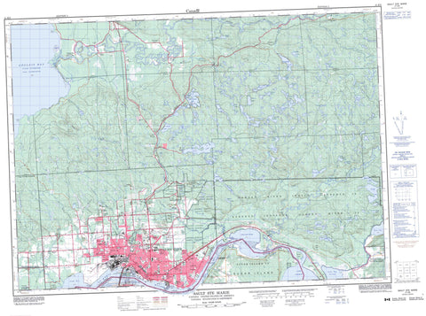
041K09 Sault Ste Marie Canada topo map, 1:50,000 scale
041K09 Sault Ste Marie NRCAN topographic map.
Includes UTM and GPS geographic coordinates (latitude and longitude). This 50k scale map is suitable for hiking, camping, and exploring, or you could frame it as a wall map.
Printed on-demand using high resolution, on heavy weight and acid free paper, or as an upgrade on a variety of synthetic materials.
Topos available on paper, Waterproof, Poly, or Tyvek. Usually shipping rolled, unless combined with other folded maps in one order.
- Product Number: NRCAN-041K09
- Parent Topo: TOPO-041K
- Map ID also known as: 041K09, 41K9, 41K09
- Unfolded Size: Approximately 26" high by 36" wide
- Weight (paper map): ca. 55 grams
- Map Type: POD NRCAN Topographic Map
- Map Scale: 1:50,000
- Geographical region: Ontario, Canada
Neighboring Maps:
All neighboring Canadian topo maps are available for sale online at 1:50,000 scale.
Purchase the smaller scale map covering this area: Topo-041K
Spatial coverage:
Topo map sheet 041K09 Sault Ste Marie covers the following places:
- Echo Bay - Goulais Bay - Leigh Bay - Marks Bay - Sand Beach - Bell Point - Bell's Point - Fenwick Point - Maple Point - Old Vessel Point - Partridge Point - Point Charles - Stony Point - North Channel - Sault Ste. Marie - High Dump - Trap Rock - Beaver Falls - Crystal Falls - Minnehaha Falls - Algoma - Anderson - Awenge - Aweres - Dennis - Deroche - Duncan - Fenwick - Hodgins - Jarvis - Kehoe - Korah - Macdonald - Parke - Pennefather - Prince - Tarentorus - VanKoughnet - Garden River 14 - Garden River Indian Reserve 14 - Rankin Location 15D - Rankin Location Indian Reserve 15D - Réserve indienne Garden River 14 - Réserve indienne Rankin Location 15D - Réserve indienne Whitefish Island - Whitefish Island - Whitefish Island Indian Reserve - Baschine Island - Cook Island - Dick Moore Island - Sand Island - Shingwauk Island - Squirrel Island - St. Mary's Island - Topsail Island - Whitefish Island - Young Island - Alexander Lake - Allard Lake - Anderson Lake - Ann Lake - Aweres Lake - Belleau Lake - Bob Chips Lake - Boss Lake - Boundary Lake - Brilliant Lake - Caribou Lake - Christman Lake - Chub Lake - Clearwater Lake - Crooked Lakes - Crystal Lake - Dead Horse Lake - DeGraff Lake - Driving Lake - Echo Lake - Elizabeth Lake - Fillion Lake - Finn Lake - Gordon Lake - Grassy Lake - Herbert Lake - Heyden Lake - Heyden Lakes - Jarvis Lake - Johnson Lake - Kaufman Lake - Kelly Lake - Lac Supérieur - Lake George - Lake One - Lake Superior - Legge Lake - Lilypad Lake - Little Lake George - Lower Island Lake - Lynch Lake - Mabel Lake - Maki Lake - Maple Lake - Maud Lake - McIntyre Lake - Meniss Lake - Midge Lake - Moss Lake - Nettleton Lake - Northland Lake - Owl Lake - Paddy Lake - Pants Lake - Phelbin Lake - Quinn Lake - Rainbow Lake - Redrock Lake - Reserve Lake - Sandy Lake - St. Joe Lake - Surette Lake - Syrette Lake - Trotter Lake - Trout Lake - Upper Island Lake - Wahbunose Lake - Weashkog Lake - White Birch Lake - Wigwas Lake - Champ de manoeuvre Korah - Korah Training Area - Clay Hill - Kaboosa Hill - Maple Ridge - Sand Hill - Korah - Macdonald, Meredith and Aberdeen Additional - Prince - Tarentorus - Goulais River Beach Ridges Conservation Reserve - Lieu historique national du Canada du Canal-de-Sault Ste. Marie - Sault Ste. Marie Canal National Historic Site of Canada - Searchmont South Forest Conservation Reserve - Gogwabik Flats - The High Dump - Murphys Rapids - Murphy's Rapids - The Rapids - Bar Creek - Bedore Creek - Bellevue Creek - Bennet Creek - Bennett Creek - Big Carp River - Clark Creek - Coldwater Creek - Cranberry Creek - Crystal Creek - Dam Creek - Dead Horse Creek - Driving Creek - East Davignon Creek - Echo River - Elm Creek - Fort Creek - Garden River - Goulais River - Kelly Creek - Lamon Creek - Leishman Creek - Little Carp River - Lower Echo River - Maple Creek - Maud Creek - Mill Creek - Northland Creek - Rainbow Creek - Rivière Ste-Marie - Robertson Creek - Root River - Sheppard Creek - Silver Creek - South Channel - Spring Creek - St. Mary River - St. Marys River - Stony Creek - Taylor Creek - Thielman Creek - West Davignon Creek - West Root River - The Big Bend - Vidal Shoals - Bayview - Bellevue - Bellevue Station - Bourdages Corner - Broadview Gardens - Brookfield - Buckley - Carpin Beach - Cedar Heights - East Korah - Eastside - Echo River - Fort Creek - French Bay - Garden River - Glendale - Goulais Bay - Goulais River - Grandview Gardens - Heyden - Huckson Corners - Island Lake - Kirby's Corner - Korah - Manitou Park - McQueen - Meadow Park - Northland - Odena - Sault Ship Canal - Steelton - Steelton - The P Patch - Bellevue Valley


