
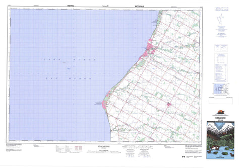
041A04 Kincardine Canada topo map, 1:50,000 scale
041A04 Kincardine NRCAN topographic map.
Includes UTM and GPS geographic coordinates (latitude and longitude). This 50k scale map is suitable for hiking, camping, and exploring, or you could frame it as a wall map.
Printed on-demand using high resolution, on heavy weight and acid free paper, or as an upgrade on a variety of synthetic materials.
Topos available on paper, Waterproof, Poly, or Tyvek. Usually shipping rolled, unless combined with other folded maps in one order.
- Product Number: NRCAN-041A04
- Parent Topo: TOPO-041A
- Map ID also known as: 041A04, 41A4, 41A04
- Unfolded Size: Approximately 26" high by 36" wide
- Weight (paper map): ca. 55 grams
- Map Type: POD NRCAN Topographic Map
- Map Scale: 1:50,000
- Geographical region: Ontario, Canada
Neighboring Maps:
All neighboring Canadian topo maps are available for sale online at 1:50,000 scale.
Purchase the smaller scale map covering this area: Topo-041A
Spatial coverage:
Topo map sheet 041A04 Kincardine covers the following places:
- Amberley Beach - Boiler Beach - Bruce Beach - Lorne Beach - Lurgan Beach - Poplar Beach - South Beach - Horton Point - Point Clark - Stoney Island - Ashfield - Bruce - Huron - Huron - Kincardine - Kinloss - Stewart Drain - Lac Huron - Lake Huron - Wyley's Hill - Bruce - Huron - Ashfield - Ashfield-Colborne-Wawanosh - Bruce - Colborne - Huron - Huron-Kinloss - Kincardine - Kincardine - Kincardine-Bruce-Tiverton - Kinloss - West Wawanosh - Lieu historique national du Canada du Phare-de-la-Pointe-Clark - Point Clark Lighthouse National Historic Site of Canada - Andrews Creek - Boyd Creek - Clark Creek - Eighteen Mile River - Kincardine Creek - Lorne Creek - North Penetangore River - Penetangore River - Pine River - Royal Oak Creek - South Pine River - Clark Reef - Tolmie Reef - Amberley - Armow - Bervie - Clarks Church - Clover Valley - Huron Ridge - Island Haven - Kincardine - Kinhuron - Lake Huron Highland - Laurier - Lochalsh - Lorne - Lorne Beach - Lurgan - Lurgan Beach - Millarton - Pine River - Point Clark - Purple Grove - Reid Corner - Reid's Corners - Ripley - Slade - Verdun


