
~ Hawaii HI topo map, 1:250000 scale, 1 X 2 Degree, Historical, 1975, updated 1977
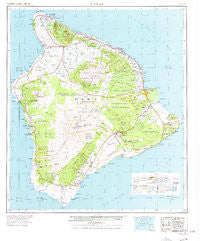
Hawaii, Hawaii, USGS topographic map dated 1975.
Includes geographic coordinates (latitude and longitude). This topographic map is suitable for hiking, camping, and exploring, or framing it as a wall map.
Printed on-demand using high resolution imagery, on heavy weight and acid free paper, or alternatively on a variety of synthetic materials.
Topos available on paper, Waterproof, Poly, or Tyvek. Usually shipping rolled, unless combined with other folded maps in one order.
- Product Number: USGS-5683291
- Free digital map download (high-resolution, GeoPDF): Hawaii, Hawaii (file size: 16 MB)
- Map Size: please refer to the dimensions of the GeoPDF map above
- Weight (paper map): ca. 55 grams
- Map Type: POD USGS Topographic Map
- Map Series: HTMC
- Map Verison: Historical
- Cell ID: 322509
- Scan ID: 349916
- Imprint Year: 1977
- Woodland Tint: Yes
- Aerial Photo Year: 1965
- Datum: Old Hawaiian
- Map Projection: Universal Transverse Mercator
- Map published by United States Geological Survey
- Map Language: English
- Scanner Resolution: 600 dpi
- Map Cell Name: Hawaii
- Grid size: 1 X 2 Degree
- Date on map: 1975
- Map Scale: 1:250000
- Geographical region: Hawaii, United States
Neighboring Maps:
All neighboring USGS topo maps are available for sale online at a variety of scales.
Spatial coverage:
Topo map Hawaii, Hawaii, covers the geographical area associated the following places:
- Waimea - Hawaiʻi Beaches Estates - Māhukona - Pāpā Bay Estates - Pāhala - Kapuʻa (historical) - Waipio - Paliʻaʻalii - Honalo - Napumaia (historical) - Pepeekeo Mill - Keālia - Niuliʻi - Keʻei - Captain Cook - Halawa - Akona - Punaluu Kahawai - Kapaahu - Mokaoku - Kūkaʻiau - Nīnole - Kukui - Piʻihonua - Leilani Estates - Kawela - Kaniahiku Village - Kealakomo (historical) - Weliweli - Hillcrest - Kapaau - Wailea - Honohina (historical) - Waipāhoehoe - Halepiula - Kehena - Eden Roc - Kuhio Village - Hāwī - Komakawai - Fern Acres - Niuʻoʻu (historical) - Hilo - Kapulena - Pāpaʻaloa - Pualaa - Keauhou - Glenwood - Kalapana (historical) - Royal Gardens (historical) - Kawainui - Kailua - Kaumana - Waiaka - Hanaipoe - Punaluʻu - Kīholo - Volcano - Kalapana Sea View Estates - Monohaa - Hoʻokena - Paukaa - ʻĀpua (historical) - Pāpaʻi (historical) - Aloha Kona - Moaula (historical) - Kaʻūpūlehu - Makapala - Palihoʻoukapapa (historical) - Wainaku - Kaimū - Ohaikea (historical) - Olelomoana (historical) - Nāʻālehu - Mahaiula - Ferndale (historical) - Pohoiki - Waikoloa - Hawaiian Acres - Kukui Village - Pepeekeo - Waikiʻi - Koae (historical) - Opihikao - Waiakahiula (historical) - Pāpaʻikou - Haina - Kahaluʻu - ʻUmikoa - Lahuipuaa (historical) - Kawailiula (historical) - Sea View - Vacationland Hawaii - Hōnaunau - Hopuwai - Kaukahōkū - Honokōhau - Kurtistown - Elevenmile Homestead - Hawaiian Ocean View
- Map Area ID: AREA20.283333318.9-156.0666667-154.8
- Northwest corner Lat/Long code: USGSNW20.2833333-156.0666667
- Northeast corner Lat/Long code: USGSNE20.2833333-154.8
- Southwest corner Lat/Long code: USGSSW18.9-156.0666667
- Southeast corner Lat/Long code: USGSSE18.9-154.8
- Northern map edge Latitude: 20.2833333
- Southern map edge Latitude: 18.9
- Western map edge Longitude: -156.0666667
- Eastern map edge Longitude: -154.8


