
~ Oahu HI topo map, 1:250000 scale, 1 X 2 Degree, Historical, 1970, updated 1973
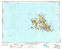
Oahu, Hawaii, USGS topographic map dated 1970.
Includes geographic coordinates (latitude and longitude). This topographic map is suitable for hiking, camping, and exploring, or framing it as a wall map.
Printed on-demand using high resolution imagery, on heavy weight and acid free paper, or alternatively on a variety of synthetic materials.
Topos available on paper, Waterproof, Poly, or Tyvek. Usually shipping rolled, unless combined with other folded maps in one order.
- Product Number: USGS-5644764
- Free digital map download (high-resolution, GeoPDF): Oahu, Hawaii (file size: 14 MB)
- Map Size: please refer to the dimensions of the GeoPDF map above
- Weight (paper map): ca. 55 grams
- Map Type: POD USGS Topographic Map
- Map Series: HTMC
- Map Verison: Historical
- Cell ID: 68943
- Scan ID: 349940
- Imprint Year: 1973
- Woodland Tint: Yes
- Visual Version Number: 1
- Survey Year: 1969
- Datum: Unstated
- Map Projection: Universal Transverse Mercator
- Map published by United States Geological Survey
- Map published by United States Army
- Map Language: English
- Scanner Resolution: 600 dpi
- Map Cell Name: Oahu
- Grid size: 1 X 2 Degree
- Date on map: 1970
- Map Scale: 1:250000
- Geographical region: Hawaii, United States
Neighboring Maps:
All neighboring USGS topo maps are available for sale online at a variety of scales.
Spatial coverage:
Topo map Oahu, Hawaii, covers the geographical area associated the following places:
- Haleʻiwa - Lāʻie - ʻAiea - Moanalua - Woodlawn - Kalakaua Homes - Pearl City - Maunalani Heights - Crestview - Waiʻanae - Āliamanu - Kahaluʻu - ʻĀhuimanu - ʻEwa Beach - Mōʻiliʻili - Punahou - ʻĀlewa Heights - Waiāhole - Kuliʻouʻou - Kamehameha Heights - Sunset Beach - Punaluʻu - Palolo Homes - Heʻeia - Kokokahi - Wilhelmina Rise - Kahuku - Village Park - Keaʻalu - Hauiki Homes - Iwilei - ʻEwa - Waipiʻo Acres - Waimānalo Beach - Wailupe - Honokai Hale - Kunia Camp - Wheeler Field - Makiki Heights - Pūʻōhala Village - Pacific Heights - Mākaha Valley - Puahala Homes - Waipiʻo - ʻĀina Haina - Ranch Camp - Waipahu - Hauʻula - Waiau - Kaʻaʻawa - Waialua - Kalihi - Kalauao - Puʻuloa - Sisal - WaiKāne - Kamehameha Homes - Mayor Wright Homes - Waimea - Pūpūkea - Hawaiʻi Kai - Pōhākupu - Dowsett Highlands - Mikilua (historical) - Kapahulu - Māʻili - Neneleʻa (historical) - Thompson Corner - Hālawa Hills - Mokumoa Island (historical) - Waialeʻe - Hickam Village - Pacific Palisades - Kāhala - Mahinui - Kaʻahmuanu Homes - Keolu Hills - Wahiawā - Renton Village - Kapolei - Hālawa Heights - Whitmore Village - Mililani Town - ʻEwa Gentry - Waimānalo - Honouliuli - Niu - Karston (historical) - Puʻunui - Kalihi Kai - Mokulēia - Foster Village - Kamoʻoloa - Kawailoa Beach - Iroquois Point - Kawela Bay - Tenney Village - Mākaha - Kahana - ʻEwa-Schofield Junction
- Map Area ID: AREA2221-159-157.5
- Northwest corner Lat/Long code: USGSNW22-159
- Northeast corner Lat/Long code: USGSNE22-157.5
- Southwest corner Lat/Long code: USGSSW21-159
- Southeast corner Lat/Long code: USGSSE21-157.5
- Northern map edge Latitude: 22
- Southern map edge Latitude: 21
- Western map edge Longitude: -159
- Eastern map edge Longitude: -157.5


