
~ Hawaii North HI topo map, 1:250000 scale, 1 X 2 Degree, Historical, 1959, updated 1959
Hawaii North, Hawaii, USGS topographic map dated 1959.
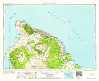
Includes geographic coordinates (latitude and longitude). This topographic map is suitable for hiking, camping, and exploring, or framing it as a wall map.
Printed on-demand using high resolution imagery, on heavy weight and acid free paper, or alternatively on a variety of synthetic materials.
Topos available on paper, Waterproof, Poly, or Tyvek. Usually shipping rolled, unless combined with other folded maps in one order.
- Product Number: USGS-5644724
- Free digital map download (high-resolution, GeoPDF): Hawaii North, Hawaii (file size: 9 MB)
- Map Size: please refer to the dimensions of the GeoPDF map above
- Weight (paper map): ca. 55 grams
- Map Type: POD USGS Topographic Map
- Map Series: HTMC
- Map Verison: Historical
- Cell ID: 68820
- Scan ID: 349920
- Imprint Year: 1959
- Woodland Tint: Yes
- Aerial Photo Year: 1941
- Datum: Unstated
- Map Projection: Transverse Mercator
- Map published by United States Geological Survey
- Map published by United States Army Corps of Engineers
- Map published by United States Army
- Map Language: English
- Scanner Resolution: 600 dpi
- Map Cell Name: Hawaii North
- Grid size: 1 X 2 Degree
- Date on map: 1959
- Map Scale: 1:250000
- Geographical region: Hawaii, United States
Neighboring Maps:
All neighboring USGS topo maps are available for sale online at a variety of scales.
Spatial coverage:
Topo map Hawaii North, Hawaii, covers the geographical area associated the following places:
- Ainaloa - Kuakini Heights - Milo Village - Keawaiki - Kealapuali - Hakalau - Paʻauilo - Makahalau - Wailea - Hillcrest - Waihou - Paauhau - Makaʻeo (historical) - Weliweli - ʻŌʻōkala - Honomu - Hilo - Kūkaʻiau - Hawaiʻi Beaches Estates - Palihoʻoukapapa (historical) - Nīnole - Kapoho - Waipio - Fern Acres - Kaʻūpūlehu - Mountain View - Kukui Village - Piʻihonua - Kaʻau - Honomakaʻu - Kainaliu - Puʻuanahulu - Mokaoku - Keaʻau - Keʻāmuku (historical) - Kapaau - Mahaiula - Honalo - Pāpaʻikou - Hawaiian Beaches - Kuhio Village - Honokōhau - Hawaiian Paradise Park - Lehua (historical) - Pāpaʻi (historical) - Wainaku - Puako - Sea View - Elevenmile Homestead - Makalawena - Kalaoa - Kawaihae - Orchidlands Estates - Halepiula - ʻAnae-hoʻomalu - Halaʻula - Huʻehuʻe - Laniākea - Akona - Onomea (historical) - Keauhou - Keanakolu - Onouli (historical) - Honokaʻa - Hāwī - Pepeekeo - Laupāhoehoe - Kukuihaele - Puopelu - Kīholo - Paliʻaʻalii - Kukui - Hikapoloa - Kawailiula (historical) - Waipāhoehoe - Welokā - Komohana Kai - Haina - Waikiʻi - Koae (historical) - Kealakekua - Makapala - Pawaina (historical) - Lahuipuaa (historical) - Kailua - Honohina (historical) - Hawaiian Acres - Aliʻi Kai - Ohia (historical) - Pulu (historical) - Niuliʻi - Honolulu Landing (historical) - Hale Pili - Pepeekeo Mill - Pauahi - Hopuwai - Puʻuʻeo - Waikui - Kaukahōkū - Waikoloa Village
- Map Area ID: AREA20.519.5-156.0833333-154.5833333
- Northwest corner Lat/Long code: USGSNW20.5-156.0833333
- Northeast corner Lat/Long code: USGSNE20.5-154.5833333
- Southwest corner Lat/Long code: USGSSW19.5-156.0833333
- Southeast corner Lat/Long code: USGSSE19.5-154.5833333
- Northern map edge Latitude: 20.5
- Southern map edge Latitude: 19.5
- Western map edge Longitude: -156.0833333
- Eastern map edge Longitude: -154.5833333


