
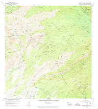
~ Waimea Canyon HI topo map, 1:24000 scale, 7.5 X 7.5 Minute, Historical, 1965, updated 1974
Waimea Canyon, Hawaii, USGS topographic map dated 1965.
Includes geographic coordinates (latitude and longitude). This topographic map is suitable for hiking, camping, and exploring, or framing it as a wall map.
Printed on-demand using high resolution imagery, on heavy weight and acid free paper, or alternatively on a variety of synthetic materials.
Topos available on paper, Waterproof, Poly, or Tyvek. Usually shipping rolled, unless combined with other folded maps in one order.
- Product Number: USGS-5644596
- Free digital map download (high-resolution, GeoPDF): Waimea Canyon, Hawaii (file size: 14 MB)
- Map Size: please refer to the dimensions of the GeoPDF map above
- Weight (paper map): ca. 55 grams
- Map Type: POD USGS Topographic Map
- Map Series: HTMC
- Map Verison: Historical
- Cell ID: 47177
- Scan ID: 349795
- Imprint Year: 1974
- Woodland Tint: Yes
- Aerial Photo Year: 1960
- Field Check Year: 1965
- Datum: Old Hawaiian
- Map Projection: Polyconic
- Map published by United States Geological Survey
- Map Language: English
- Scanner Resolution: 600 dpi
- Map Cell Name: Waimea Canyon
- Grid size: 7.5 X 7.5 Minute
- Date on map: 1965
- Map Scale: 1:24000
- Geographical region: Hawaii, United States
Neighboring Maps:
All neighboring USGS topo maps are available for sale online at a variety of scales.
Spatial coverage:
Topo map Waimea Canyon, Hawaii, covers the geographical area associated the following places:
- Kukui Trail - Waiʻalae Cabin - Mōhihi Stream - Koiohi - Hipalau Camp - Kāhililoa - Kepani Reservoir - Halepaʻakai Stream - Mokuone Valley - Wahane Valley - Peʻapeʻa - Waiʻalae Stream - ‘Ōpaewela Valley - Waiānuenue Falls - Nonopahu Ridge - Waiahulu Stream - Ohulelua Ridge - Kalehuahakihaki - Kaumakani-Hanapepe Division - Oneopaewa Valley - Kōkeʻe Stream - Halemanu Stream - Loli River - Nāwaimaka Valley - Kaanakeakua - Kapōhakukilomanu Stream - Kahana Stream - Kaʻala - Kipole - Makaweli - Waiau Stream - Nakanukalolo Ridge - Kaʻaha - Wiliwili Camp - Kaumahaloa - Koholoina Stream - Lonomea Camp - Koaiʻe Stream - Kahōluamanu - Kaukelei - Waipoʻo Falls - Nāwaimaka Stream - Olokele Canyon - Halekua Stream - ʻĀwini Stream - Kawaipapa Valley - Kahana Valley - Keanapahu - Waiānuenue Stream - Kawai Iki Ridge - ʻĀwini Falls - Poʻololoʻole - Kukui - Kawai Iki Valley - Kapukapaia Ridge - Kaluahāʻula Ridge - Kawaipuua Stream - Kipalau Valley - Puʻukapele - Poʻomau Stream - ‘Ōma‘o Valley - Mauka Powerhouse - Kaupuaʻa - Koaiʻe Camp - Kaluaokalani Valley - Mōhihi Falls - Iliau Nature Loop - Poʻokaeha - Halehaha Stream - Kaluahāʻula Camp - Mokuone Stream - Keʻāpua - Olokele River - Waiʻalae Falls - Waimea Canyon State Park - Puʻukī - Puʻukī Waiʻalae Trail - Waimea Canyon Lookout - Kohua Ridge - Waimea District - Koaiʻe Canyon Trail - Kahekapō‘ele‘ele Valley - Hipalau Valley - Nāhaleokoʻo Ridge - Kaʻou - Keanaʻihiʻihi - Poachers Camp - Kāhililoa - ʻOʻopulele Falls - Waikaka Falls
- Map Area ID: AREA22.116666721.9916667-159.6666667-159.5416667
- Northwest corner Lat/Long code: USGSNW22.1166667-159.6666667
- Northeast corner Lat/Long code: USGSNE22.1166667-159.5416667
- Southwest corner Lat/Long code: USGSSW21.9916667-159.6666667
- Southeast corner Lat/Long code: USGSSE21.9916667-159.5416667
- Northern map edge Latitude: 22.1166667
- Southern map edge Latitude: 21.9916667
- Western map edge Longitude: -159.6666667
- Eastern map edge Longitude: -159.5416667


