
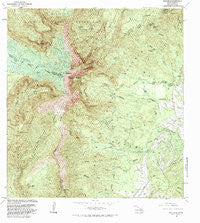
~ Waialeale HI topo map, 1:24000 scale, 7.5 X 7.5 Minute, Historical, 1983, updated 1984
Waialeale, Hawaii, USGS topographic map dated 1983.
Includes geographic coordinates (latitude and longitude). This topographic map is suitable for hiking, camping, and exploring, or framing it as a wall map.
Printed on-demand using high resolution imagery, on heavy weight and acid free paper, or alternatively on a variety of synthetic materials.
Topos available on paper, Waterproof, Poly, or Tyvek. Usually shipping rolled, unless combined with other folded maps in one order.
- Product Number: USGS-5644560
- Free digital map download (high-resolution, GeoPDF): Waialeale, Hawaii (file size: 19 MB)
- Map Size: please refer to the dimensions of the GeoPDF map above
- Weight (paper map): ca. 55 grams
- Map Type: POD USGS Topographic Map
- Map Series: HTMC
- Map Verison: Historical
- Cell ID: 47173
- Scan ID: 349770
- Imprint Year: 1984
- Woodland Tint: Yes
- Visual Version Number: 1
- Aerial Photo Year: 1978
- Edit Year: 1983
- Field Check Year: 1981
- Datum: Old Hawaiian
- Map Projection: Transverse Mercator
- Map published by United States Geological Survey
- Map Language: English
- Scanner Resolution: 600 dpi
- Map Cell Name: Waialeale
- Grid size: 7.5 X 7.5 Minute
- Date on map: 1983
- Map Scale: 1:24000
- Geographical region: Hawaii, United States
Neighboring Maps:
All neighboring USGS topo maps are available for sale online at a variety of scales.
Spatial coverage:
Topo map Waialeale, Hawaii, covers the geographical area associated the following places:
- North Intake Ditch - Kaumanalehua - Waipunaea Stream - Pōhakupele - ʻIliʻiliʻula Stream - Kalalea - Hāliʻi Falls - Waiahi ʻIliʻiliʻula Ditch - Makaopihi - Kuaohukini - Palikea Stream - Alakaʻi Swamp - Kilohana Crater - Kuahua - Kanaha Ditch - Kaʻawako Heiau - Maunaʻou - Kapalaoa - Pālehua - Kualapa - Hanalei - Uhauʻiole Falls - Waiahi Stream - Kaulu Stream - Hauhili Stream - Mahinakēhau Ridge - Kalaluapuu - Paliemo Valley - Līhuʻe District - Keanaʻāwī Ridge - Palikea - KIPU-FM (Lihue) - Halulu Falls - Kalaluanahelehele - Kīloa - KFMN-FM (Lihue) - Kauaʻi - ʻIole Stream - ʻIliʻiliʻula North Wailua Ditch - Kapaka Nui Falls - Waiaka Stream - Kuilau Ridge - Kāhili Falls - Kamanu - Kapoki - Kaʻāpoko Stream - Keahua - Upper Powerhouse - Līhuʻe-Kōloa Forest Reserve - Waikoko Stream - Hanahanapuni - ʻIole - Puʻukī - Kapakaiki Falls - Waiʻaleʻale - Kawaikini - Hāliʻi Stream - Hinalele Falls - Lower Powerhouse - Maheo
- Map Area ID: AREA22.116666721.9916667-159.5416667-159.4166667
- Northwest corner Lat/Long code: USGSNW22.1166667-159.5416667
- Northeast corner Lat/Long code: USGSNE22.1166667-159.4166667
- Southwest corner Lat/Long code: USGSSW21.9916667-159.5416667
- Southeast corner Lat/Long code: USGSSE21.9916667-159.4166667
- Northern map edge Latitude: 22.1166667
- Southern map edge Latitude: 21.9916667
- Western map edge Longitude: -159.5416667
- Eastern map edge Longitude: -159.4166667


