
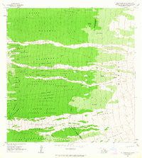
~ Puu Pohakuloa HI topo map, 1:24000 scale, 7.5 X 7.5 Minute, Historical, 1963, updated 1964
Puu Pohakuloa, Hawaii, USGS topographic map dated 1963.
Includes geographic coordinates (latitude and longitude). This topographic map is suitable for hiking, camping, and exploring, or framing it as a wall map.
Printed on-demand using high resolution imagery, on heavy weight and acid free paper, or alternatively on a variety of synthetic materials.
Topos available on paper, Waterproof, Poly, or Tyvek. Usually shipping rolled, unless combined with other folded maps in one order.
- Product Number: USGS-5644466
- Free digital map download (high-resolution, GeoPDF): Puu Pohakuloa, Hawaii (file size: 12 MB)
- Map Size: please refer to the dimensions of the GeoPDF map above
- Weight (paper map): ca. 55 grams
- Map Type: POD USGS Topographic Map
- Map Series: HTMC
- Map Verison: Historical
- Cell ID: 36705
- Scan ID: 349721
- Imprint Year: 1964
- Woodland Tint: Yes
- Aerial Photo Year: 1961
- Field Check Year: 1963
- Datum: Old Hawaiian
- Map Projection: Polyconic
- Map published by United States Geological Survey
- Map Language: English
- Scanner Resolution: 600 dpi
- Map Cell Name: Puupohakuloa
- Grid size: 7.5 X 7.5 Minute
- Date on map: 1963
- Map Scale: 1:24000
- Geographical region: Hawaii, United States
Neighboring Maps:
All neighboring USGS topo maps are available for sale online at a variety of scales.
Spatial coverage:
Topo map Puu Pohakuloa, Hawaii, covers the geographical area associated the following places:
- Kaʻohe Ranch - Waikākuʻu - Waiea - Kaʻapuna - Lumiawai Waterhole - Haukalua - South Kona Forest Reserve - Kaʻohe 4 - Kona Paradise Volunteer Fire Station 06B - Polewai Waterhole - Keanapaʻakai - Maunaoni - Kaʻapuna Lava Flow of 1950 - Kukuiopaʻe Homesteads - ʻŌlelomoana 1 - ʻŌlelomoana Homesteads - Puʻupōhakuloa - Olelomoana-Opihihali Tract - ʻŌlelomoana 2 - Kaʻohe 1-3 - Pāhoehoe 1 - Kukuiopaʻe - Hooper Camp - Pāhoehoe 1-4 - South Kona Division - Honokua Lava Flow of 1950 - Honokua - Opihihali Two - Kaʻohe 5 - Opihihali One - Pāhoehoe 2
- Map Area ID: AREA19.37519.25-155.875-155.75
- Northwest corner Lat/Long code: USGSNW19.375-155.875
- Northeast corner Lat/Long code: USGSNE19.375-155.75
- Southwest corner Lat/Long code: USGSSW19.25-155.875
- Southeast corner Lat/Long code: USGSSE19.25-155.75
- Northern map edge Latitude: 19.375
- Southern map edge Latitude: 19.25
- Western map edge Longitude: -155.875
- Eastern map edge Longitude: -155.75


