
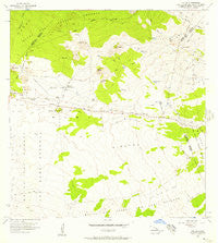
~ Puu Oo HI topo map, 1:24000 scale, 7.5 X 7.5 Minute, Historical, 1956, updated 1957
Puu Oo, Hawaii, USGS topographic map dated 1956.
Includes geographic coordinates (latitude and longitude). This topographic map is suitable for hiking, camping, and exploring, or framing it as a wall map.
Printed on-demand using high resolution imagery, on heavy weight and acid free paper, or alternatively on a variety of synthetic materials.
Topos available on paper, Waterproof, Poly, or Tyvek. Usually shipping rolled, unless combined with other folded maps in one order.
- Product Number: USGS-5644460
- Free digital map download (high-resolution, GeoPDF): Puu Oo, Hawaii (file size: 8 MB)
- Map Size: please refer to the dimensions of the GeoPDF map above
- Weight (paper map): ca. 55 grams
- Map Type: POD USGS Topographic Map
- Map Series: HTMC
- Map Verison: Historical
- Cell ID: 36704
- Scan ID: 349718
- Imprint Year: 1957
- Woodland Tint: Yes
- Aerial Photo Year: 1954
- Field Check Year: 1956
- Datum: Old Hawaiian
- Map Projection: Polyconic
- Map published by United States Geological Survey
- Map Language: English
- Scanner Resolution: 600 dpi
- Map Cell Name: Puuoo
- Grid size: 7.5 X 7.5 Minute
- Date on map: 1956
- Map Scale: 1:24000
- Geographical region: Hawaii, United States
Neighboring Maps:
All neighboring USGS topo maps are available for sale online at a variety of scales.
Spatial coverage:
Topo map Puu Oo, Hawaii, covers the geographical area associated the following places:
- Puʻu Oo Horse Trail - Puʻunēnē - Homuʻula-Upper Piʻihonua Hawaiian Home Land - Loaloa - Kalaieha - Omaokoili - Humuʻula Saddle - Hilo Trail - Hawaii Region - 2-digit Hydrologic Unit Code - 20 - Puʻukole - Puʻuʻōʻō - Humuʻula Sheep Station - Puʻuhuluhulu - Huikau - ʻĀinahou - Hoʻokomo - Puʻukahiliku - Puʻuʻōʻō Ranch
- Map Area ID: AREA19.7519.625-155.5-155.375
- Northwest corner Lat/Long code: USGSNW19.75-155.5
- Northeast corner Lat/Long code: USGSNE19.75-155.375
- Southwest corner Lat/Long code: USGSSW19.625-155.5
- Southeast corner Lat/Long code: USGSSE19.625-155.375
- Northern map edge Latitude: 19.75
- Southern map edge Latitude: 19.625
- Western map edge Longitude: -155.5
- Eastern map edge Longitude: -155.375


