
~ Mauna Kea HI topo map, 1:24000 scale, 7.5 X 7.5 Minute, Historical, 1982, updated 1982
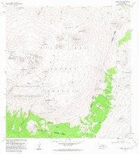
Mauna Kea, Hawaii, USGS topographic map dated 1982.
Includes geographic coordinates (latitude and longitude). This topographic map is suitable for hiking, camping, and exploring, or framing it as a wall map.
Printed on-demand using high resolution imagery, on heavy weight and acid free paper, or alternatively on a variety of synthetic materials.
Topos available on paper, Waterproof, Poly, or Tyvek. Usually shipping rolled, unless combined with other folded maps in one order.
- Product Number: USGS-5644202
- Free digital map download (high-resolution, GeoPDF): Mauna Kea, Hawaii (file size: 10 MB)
- Map Size: please refer to the dimensions of the GeoPDF map above
- Weight (paper map): ca. 55 grams
- Map Type: POD USGS Topographic Map
- Map Series: HTMC
- Map Verison: Historical
- Cell ID: 28054
- Scan ID: 349575
- Imprint Year: 1982
- Woodland Tint: Yes
- Aerial Photo Year: 1978
- Edit Year: 1982
- Field Check Year: 1981
- Datum: Old Hawaiian
- Map Projection: Transverse Mercator
- Map published by United States Geological Survey
- Map Language: English
- Scanner Resolution: 600 dpi
- Map Cell Name: Mauna Kea
- Grid size: 7.5 X 7.5 Minute
- Date on map: 1982
- Map Scale: 1:24000
- Geographical region: Hawaii, United States
Neighboring Maps:
All neighboring USGS topo maps are available for sale online at a variety of scales.
Spatial coverage:
Topo map Mauna Kea, Hawaii, covers the geographical area associated the following places:
- Puʻukahinahina - Mauna Kea Observatories - Kilohana - Hale Pohaku Ranger Station - Puʻupalaolelo - Puʻulilinoe - Puʻukeoneheheʻe - Mauna Kea-Humuʻula Trail - Puʻuwēkiu - Puʻukawaiwai - Kahinahina Trail - Puʻupoepoe - Kaaliali Trail - Puʻuholei - Puʻupoliʻahu - Lake Waiau - Puʻuhaukea - Papalekoki - Puʻuʻulaʻulua - Keanakākoʻi (historical) - Mauna Kea Forest Reserve - Puʻuloa - Puʻuhauʻoki - Puʻuwaiau - Puʻukanakaleonui - Red Hill - Puʻupōhaku - Puʻumāhoe - Mauna Kea Ice Age Natural Area Reserve - Puʻukaupakuhale - Mauna Kea Umikoa Trail - Puʻuhaiwahine - Kahinahina Forest Cabin - Puʻuhoaka - Puʻuala - Puʻukalepeamoa - Mauna Kea State Park - Halepōhaku Area - Puʻumākanaka - Puʻukoʻokoʻolau - Mauna Kea - Humuʻula Hawaiian Home Land (historical) - Puʻukea - Puʻulehu
- Map Area ID: AREA19.87519.75-155.5-155.375
- Northwest corner Lat/Long code: USGSNW19.875-155.5
- Northeast corner Lat/Long code: USGSNE19.875-155.375
- Southwest corner Lat/Long code: USGSSW19.75-155.5
- Southeast corner Lat/Long code: USGSSE19.75-155.375
- Northern map edge Latitude: 19.875
- Southern map edge Latitude: 19.75
- Western map edge Longitude: -155.5
- Eastern map edge Longitude: -155.375


