
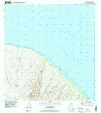
~ Makalau HI topo map, 1:24000 scale, 7.5 X 7.5 Minute, Historical, 1991, updated 2000
Makalau, Hawaii, USGS topographic map dated 1991.
Includes geographic coordinates (latitude and longitude). This topographic map is suitable for hiking, camping, and exploring, or framing it as a wall map.
Printed on-demand using high resolution imagery, on heavy weight and acid free paper, or alternatively on a variety of synthetic materials.
Topos available on paper, Waterproof, Poly, or Tyvek. Usually shipping rolled, unless combined with other folded maps in one order.
- Product Number: USGS-5644148
- Free digital map download (high-resolution, GeoPDF): Makalau, Hawaii (file size: 8 MB)
- Map Size: please refer to the dimensions of the GeoPDF map above
- Weight (paper map): ca. 55 grams
- Map Type: POD USGS Topographic Map
- Map Series: HTMC
- Map Verison: Historical
- Cell ID: 395534
- Scan ID: 349548
- Imprint Year: 2000
- Woodland Tint: Yes
- Aerial Photo Year: 1991
- Datum: NAD83
- Map Projection: Universal Transverse Mercator
- Map published by United States Geological Survey
- Map Language: English
- Scanner Resolution: 600 dpi
- Map Cell Name: Makalau
- Grid size: 7.5 X 7.5 Minute
- Date on map: 1991
- Map Scale: 1:24000
- Geographical region: Hawaii, United States
Neighboring Maps:
All neighboring USGS topo maps are available for sale online at a variety of scales.
Spatial coverage:
Topo map Makalau, Hawaii, covers the geographical area associated the following places:
- Keomuku - Halulu Gulch - Wahane Gulch - Puu Kawelo - Federation Camp - Kalakala - Hauola - Kikalapaʻakea Point - Puu Mahana - Kaʻikena - Hāʻua - Wāwaekū - Iamo - Lānaʻi - Poaiwa - Hā‘ua Gulch - Maunalei - Kuahua Gulch - Kahōkūnui - Laewahie - Waiakapuaa - Ka Lanakila o Ka Malamalama Church - Maunalei - Halulu - Kūkui Point - Laehī - Maunalei Gulch - Ka‘ā Gulch - Kauiki - Poaiwa Gulch - Mahana - Hinuhinu Pali - Nāhoko Gulch - Kuahua - Hauola Gulch - Naio Gulch - Nāhoko - Kaa Fishpond - Koele Keomuku Trail - Kaiolohia Bay - Kākaʻalani
- Map Area ID: AREA20.97520.85-156.9416667-156.8166667
- Northwest corner Lat/Long code: USGSNW20.975-156.9416667
- Northeast corner Lat/Long code: USGSNE20.975-156.8166667
- Southwest corner Lat/Long code: USGSSW20.85-156.9416667
- Southeast corner Lat/Long code: USGSSE20.85-156.8166667
- Northern map edge Latitude: 20.975
- Southern map edge Latitude: 20.85
- Western map edge Longitude: -156.9416667
- Eastern map edge Longitude: -156.8166667


