
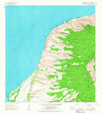
~ Makaha Point HI topo map, 1:24000 scale, 7.5 X 7.5 Minute, Historical, 1965, updated 1967
Makaha Point, Hawaii, USGS topographic map dated 1965.
Includes geographic coordinates (latitude and longitude). This topographic map is suitable for hiking, camping, and exploring, or framing it as a wall map.
Printed on-demand using high resolution imagery, on heavy weight and acid free paper, or alternatively on a variety of synthetic materials.
Topos available on paper, Waterproof, Poly, or Tyvek. Usually shipping rolled, unless combined with other folded maps in one order.
- Product Number: USGS-5644132
- Free digital map download (high-resolution, GeoPDF): Makaha Point, Hawaii (file size: 11 MB)
- Map Size: please refer to the dimensions of the GeoPDF map above
- Weight (paper map): ca. 55 grams
- Map Type: POD USGS Topographic Map
- Map Series: HTMC
- Map Verison: Historical
- Cell ID: 27304
- Scan ID: 349542
- Imprint Year: 1967
- Woodland Tint: Yes
- Aerial Photo Year: 1960
- Survey Year: 1965
- Datum: Old Hawaiian
- Map Projection: Polyconic
- Map published by United States Geological Survey
- Map Language: English
- Scanner Resolution: 600 dpi
- Map Cell Name: Makaha Point
- Grid size: 7.5 X 7.5 Minute
- Date on map: 1965
- Map Scale: 1:24000
- Geographical region: Hawaii, United States
Neighboring Maps:
All neighboring USGS topo maps are available for sale online at a variety of scales.
Spatial coverage:
Topo map Makaha Point, Hawaii, covers the geographical area associated the following places:
- Puʻuohanalei - Ka‘ula‘ula Valley - Nu‘alolo Valley - Miloli‘i Valley - Mākaha Ridge - Hikimoe Valley - Kepapa Spring - Kopakaka Ridge - Puʻuhinahina - Lapa Picnic Area - Paaiki Falls - Nuʻalolokai State Park - Miloliʻi Ridge - Puʻukapele Forest Reserve - Pine Forest Drive Picnic Area - Polihale Spring - Kolo Ridge - Saki Mana (historical) - Pa‘aiki Valley - Kākiʻokeʻokeʻo Picnic Area - Polihale Ridge - Puanaiea Point - Hā‘ele‘ele Valley - Mākaha Valley - Anaki - Polihale State Park - Puʻulua - Hikimoe Ridge - Nohili Dune - Kaʻahole Valley - Mākaha Point - Kokee Instrumentation Station - ‘Ōhai‘ula Valley - ʻAwaʻawapuhi Stream - Nuʻalolo Stream - Lapa Ridge - Kaluanamā‘ulu Valley - Queens Bath - Puʻuhinahina Lookout - ʻAwaʻawapuhi Trail - ‘Awa‘awapuhi Valley - Ku‘ia Valley - Nohili Point - Kōkeʻe Ditch - Nualolo Reef - Keawanui Landing - Lua Reservoir - Kā‘aweiki Valley - Ka‘anamahuna Valley - Kapāʻula Heiau - Honopu Arch - Barking Sands - Saki Mana Shaft - Kauhao Ridge - Kāʻaweiki Ridge - Makuaiki Point - Papaʻalai - Kāʻana - Nuʻalolo Trail - Kekaha-Waimea Division - Milolii - ʻŌhaiʻula Ridge - Waiakamo‘o Valley - Kauhao Valley - Polihale Heiau - Nualolo Kai Beach - Halemanu - Hāʻeleʻele Ridge - Kahoaloha Valley - Miloliʻi Beach - Honopu Beach - Miloliʻi State Park - Mākole - Honopū Valley - Kawai‘ula Valley - Keawanui - Kuʻia Natural Area Reserve - Alapiʻi Point - Mahanaloa Valley - Po‘opo‘oiki Valley
- Map Area ID: AREA22.183333322.0583333-159.7916667-159.6666667
- Northwest corner Lat/Long code: USGSNW22.1833333-159.7916667
- Northeast corner Lat/Long code: USGSNE22.1833333-159.6666667
- Southwest corner Lat/Long code: USGSSW22.0583333-159.7916667
- Southeast corner Lat/Long code: USGSSE22.0583333-159.6666667
- Northern map edge Latitude: 22.1833333
- Southern map edge Latitude: 22.0583333
- Western map edge Longitude: -159.7916667
- Eastern map edge Longitude: -159.6666667


