
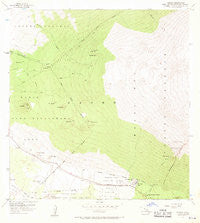
~ Ahumoa HI topo map, 1:24000 scale, 7.5 X 7.5 Minute, Historical, 1956, updated 1970
Ahumoa, Hawaii, USGS topographic map dated 1956.
Includes geographic coordinates (latitude and longitude). This topographic map is suitable for hiking, camping, and exploring, or framing it as a wall map.
Printed on-demand using high resolution imagery, on heavy weight and acid free paper, or alternatively on a variety of synthetic materials.
Topos available on paper, Waterproof, Poly, or Tyvek. Usually shipping rolled, unless combined with other folded maps in one order.
- Product Number: USGS-5643500
- Free digital map download (high-resolution, GeoPDF): Ahumoa, Hawaii (file size: 9 MB)
- Map Size: please refer to the dimensions of the GeoPDF map above
- Weight (paper map): ca. 55 grams
- Map Type: POD USGS Topographic Map
- Map Series: HTMC
- Map Verison: Historical
- Cell ID: 299
- Scan ID: 349200
- Imprint Year: 1970
- Woodland Tint: Yes
- Aerial Photo Year: 1954
- Field Check Year: 1956
- Datum: Old Hawaiian
- Map Projection: Polyconic
- Map published by United States Geological Survey
- Map Language: English
- Scanner Resolution: 600 dpi
- Map Cell Name: Ahumoa
- Grid size: 7.5 X 7.5 Minute
- Date on map: 1956
- Map Scale: 1:24000
- Geographical region: Hawaii, United States
Neighboring Maps:
All neighboring USGS topo maps are available for sale online at a variety of scales.
Spatial coverage:
Topo map Ahumoa, Hawaii, covers the geographical area associated the following places:
- Puʻukea - Hopukani Springs - Puʻuokau - Puʻukoko - Pōhakuloa Ranger Station - Puʻunanaha - Puʻupōhakuloa - Waihū Spring - Pōhakuloa Gulch - Mauna Kea State Park - Puʻumanaʻo - Puʻumaʻau - Ahumoa - Puʻulāʻau - Kaʻohe Game Management Area - Puʻuokauha - Puʻuʻulaʻula - Bradshaw Army Airfield - Puu Nana - Pōhakuloa Game Management Area - Liloe Spring - Pōhakuloa Camp - Paauhau-Paauilo Division - Puʻuʻaiʻākala - Nau
- Map Area ID: AREA19.87519.75-155.625-155.5
- Northwest corner Lat/Long code: USGSNW19.875-155.625
- Northeast corner Lat/Long code: USGSNE19.875-155.5
- Southwest corner Lat/Long code: USGSSW19.75-155.625
- Southeast corner Lat/Long code: USGSSE19.75-155.5
- Northern map edge Latitude: 19.875
- Southern map edge Latitude: 19.75
- Western map edge Longitude: -155.625
- Eastern map edge Longitude: -155.5


