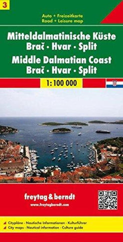
Mittledalmatinische Küste : Bra : Hvar : Split = Middle Dalmatian Coast : Bra : Hvar : Split
The Dalmatian Coast of Croatia from Split southwards to Gradec on a detailed map at 1:100,000 from Freytag & Berndt with large icons indicating various facilities including campsites and beaches, ferry connections, etc.
Coverage includes the islands of Brac, Hvar, Vis, Korcula and Lastovo, plus the northern part of the Peljesac peninsula. The map shows local roads and indicates ferry connections. Icons mark various facilities such as campsites, beaches and marinas, as well as places of interest. The map has latitude and longitude lines but without providing the coordinates. Map legend includes English.
Street plans show Split, Hvar, Korcula and Makarska. On the reverse there is a guide to the area, in English, with plans of local marinas, etc. Please note: this title is not a nautical chart for sailing.
- Product Number: FB_CRO_COAS_3_14
- Reference Product Number: 2032085M
- ISBN: 9783850849982
- Date of Publication: 6/1/2014
- Folded Size: 10.24 inches high by 5.12 inches wide
- Unfolded (flat) Size: 28.35 inches high by 44.88 inches wide
- Map format: Folded
- Map type: Trade Maps - Travel
- Geographical region: Croatia