
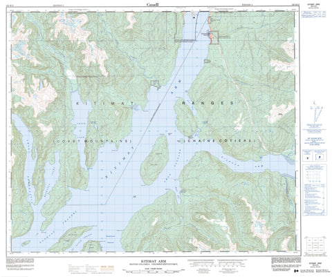
103H15 Kitimat Arm Canada topo map, 1:50,000 scale
103H15 Kitimat Arm NRCAN topographic map.
Includes UTM and GPS geographic coordinates (latitude and longitude). This 50k scale map is suitable for hiking, camping, and exploring, or you could frame it as a wall map.
Printed on-demand using high resolution, on heavy weight and acid free paper, or as an upgrade on a variety of synthetic materials.
Topos available on paper, Waterproof, Poly, or Tyvek. Usually shipping rolled, unless combined with other folded maps in one order.
- Product Number: NRCAN-103H15
- Parent Topo: TOPO-103H
- Map ID also known as: 103H15
- Unfolded Size: Approximately 26" high by 36" wide
- Weight (paper map): ca. 55 grams
- Map Type: POD NRCAN Topographic Map
- Map Scale: 1:50,000
- Geographical region: British Columbia, Canada
Neighboring Maps:
All neighboring Canadian topo maps are available for sale online at 1:50,000 scale.
Purchase the smaller scale map covering this area: Topo-103H
Spatial coverage:
Topo map sheet 103H15 Kitimat Arm covers the following places:
- Atkins Bay - Clio Bay - Dawson Arm - Eagle Bay - Emsley Cove - Gilttoyees Inlet - Gobeil Bay - Kildala Arm - Kitimat Arm - Kitimat Harbour - Miskatla Inlet - MK Bay - Clio Point - Coste Point - Emsley Point - Hilton Point - Hopkins Point - Kersey Point - Legeak Point - Louis Point - Markland Point - Point Ashton - Raley Point - Steel Point - Walbran Point - Amos Passage - Devastation Channel - Douglas Channel - Loretta Channel - Jesse Falls - Bees Indian Reserve 6 - Bish Indian Reserve 6 - Henderson's Ranch Indian Reserve 11 - Kitamaat Indian Reserve 2 - Kitasa Indian Reserve 7 - Kitimat Indian Reserve 2 - Kitisa Indian Reserve 7 - Kuaste (Mud Bay)(Kildala Arm) Indian Reserve 8 - Réserve indienne Bees 6 - Réserve indienne Bish 6 - Réserve indienne Henderson's Ranch 11 - Réserve indienne Kitamaat 2 - Réserve indienne Kitasa 7 - Réserve indienne Kitimat 2 - Réserve indienne Kitisa 7 - Réserve indienne Kuaste (Mud Bay)(Kildala Arm) 8 - Réserve indienne Tosehka (Eagle Bay) 12 - Réserve indienne Walth 3 - Réserve indienne Wawelth 3 - Tosehka (Eagle Bay) Indian Reserve 12 - Walth Indian Reserve 3 - Wawelth Indian Reserve 3 - Coste Island - Emilia Island - Gobeil Island - Loretta Island - Maitland Island - Jesse Lake - Chaîne Côtière - Coast Mountains - Haisla Mountain - Kitimat Ranges - Photograph Mountain - Regional District of Kitimat-Stikine - Bish Creek - Bolton Creek - Dala River - Deer Creek - Emsley Creek - Falls Creek - Falls River - Hugh Creek - Jesse Creek - Moore Creek - Morrison Creek - Power Creek - Wathl Creek - Wathlsto Creek - Brentzen Rock - Coste Rocks - Nanakwa Shoal - Haisla - Kitamaat Village - Kitimat Mission


