
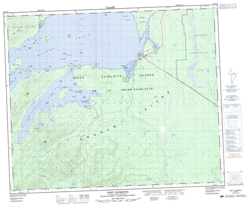
103F09 Port Clements Canada topo map, 1:50,000 scale
103F09 Port Clements NRCAN topographic map.
Includes UTM and GPS geographic coordinates (latitude and longitude). This 50k scale map is suitable for hiking, camping, and exploring, or you could frame it as a wall map.
Printed on-demand using high resolution, on heavy weight and acid free paper, or as an upgrade on a variety of synthetic materials.
Topos available on paper, Waterproof, Poly, or Tyvek. Usually shipping rolled, unless combined with other folded maps in one order.
- Product Number: NRCAN-103F09
- Parent Topo: TOPO-103F
- Map ID also known as: 103F09, 103F9
- Unfolded Size: Approximately 26" high by 36" wide
- Weight (paper map): ca. 55 grams
- Map Type: POD NRCAN Topographic Map
- Map Scale: 1:50,000
- Geographical region: British Columbia, Canada
Neighboring Maps:
All neighboring Canadian topo maps are available for sale online at 1:50,000 scale.
Purchase the smaller scale map covering this area: Topo-103F
Spatial coverage:
Topo map sheet 103F09 Port Clements covers the following places:
- Buckley Cove - Cowhoe Bay - Ferguson Bay - Juskatla Inlet - Kumdis Bay - Mamin Bay - Masset Inlet - Shannon Bay - Stewart Bay - Stilique Bay - Yakoun Bay - Yestalton Bay - Echinus Point - Makai Point - Martin Point - Parker Point - Strathdang Kwun - Juskatla Narrows - Masset Sound - Ain Indian Reserve 6 - Lanas Indian Reserve 4 - Mammin River Indian Reserve 25 - Réserve indienne Ain 6 - Réserve indienne Lanas 4 - Réserve indienne Mammin River 25 - Réserve indienne Satunquin 5 - Satunquin Indian Reserve 5 - Cowley Islands - Dawson Islands - Deasy Island - Fraser Island - Graham Island - Gray Island - Harrison Island - Harrison Islands - Îles de la Reine-Charlotte - Kumdis Island - Kwaikans Island - Learmonth Island - Mamin Islets - McCreight Island - Modeets Islands - Ohala Islets - Powell Island - Queen Charlotte Islands - Richards Island - Ross Island - Ross Islet - Ross Islets - Seegay Islets - Simpson Island - Smyth Island - Steilta Islets - Wathus Island - Wharton Island - Wiah Island - Bird Lake - Collinson Lake - Hickey Lake - Little Lake - Loon Lake - Mayer Lake - New Year Lake - Pam Lake - Paul Lake - Juskatla Mountain - McKay Range - Mount Begbie - Queen Charlotte Mountains - Towustasin Hill - Naikoon Park - Skidegate Plateau - Ain River - Blackbear Creek - Blackwater Creek - Canoe Creek - Canyon Creek - Cohoe Creek - Copp Creek - Datlamen Creek - Florence Creek - Gold Creek - Gosse Creek - Hoodoo Creek - Kumdis Creek - Log Creek - Mamin River - Mayer River - Tlell River - Yakoun River - Kumdis Slough - Borrowman Shoals - Cowley Rock - Harrison Reef - Koutz Rock - Mackie Rock - McCreight Rock - Sinclair Rock - Stubbs Rock - Juskatla - Shannon Bay - Port Clements


