
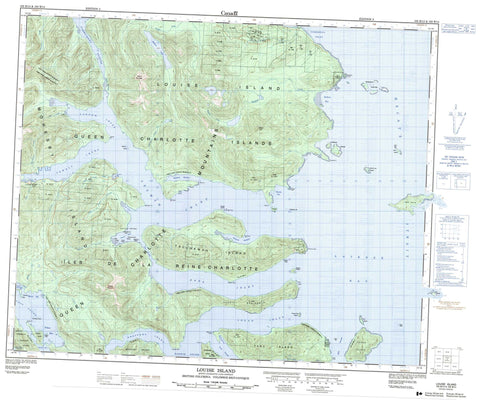
103B13 Louise Island Canada topo map, 1:50,000 scale
103B13 Louise Island NRCAN topographic map.
Includes UTM and GPS geographic coordinates (latitude and longitude). This 50k scale map is suitable for hiking, camping, and exploring, or you could frame it as a wall map.
Printed on-demand using high resolution, on heavy weight and acid free paper, or as an upgrade on a variety of synthetic materials.
Topos available on paper, Waterproof, Poly, or Tyvek. Usually shipping rolled, unless combined with other folded maps in one order.
- Product Number: NRCAN-103B13
- Parent Topo: TOPO-103B
- Map ID also known as: 103B13
- Unfolded Size: Approximately 26" high by 36" wide
- Weight (paper map): ca. 55 grams
- Map Type: POD NRCAN Topographic Map
- Map Scale: 1:50,000
- Geographical region: British Columbia, Canada
Neighboring Maps:
All neighboring Canadian topo maps are available for sale online at 1:50,000 scale.
Purchase the smaller scale map covering this area: Topo-103B
Spatial coverage:
Topo map sheet 103B13 Louise Island covers the following places:
- Barrier Bay - Botany Bay - Botany Inlet - Breaker Bay - Carmichael Arm - Cecil Cove - Crescent Inlet - Cumshewa Inlet - Dana Inlet - Fairfax Inlet - Lagoon Inlet - Laskeek Bay - Logan Inlet - Pacofi Bay - Rockfish Harbour - Selwyn Inlet - Sewell Inlet - Skedans Bay - Stalkungi Cove - Tasoo Harbour - Tasu Sound - Thurston Harbour - Trotter Bay - Two Mountain Bay - Wilson Bay - Wright Inlet - Alford Point - Alfred Point - Corlett Peninsula - Dass Point - Girard Point - Harbridge Point - Heming Head - Kilmington Point - Klue Point - Kwun Point - McGee Point - Nelson Point - Porter Head - Selwyn Point - Sewell Point - Skedans Point - Stalkungi Point - Tangil Peninsula - Thompson Point - Thomson Point - Triumph Point - Vertical Point - Wester Point - White Point - Carmichael Passage - Dana Passage - Darwin Sound - Hecate Strait - Klue Passage - Louise Narrows - Tanu Passage - Réserve indienne Skedance 8 - Réserve indienne Tanoo 9 - Skedance Indian Reserve 8 - Tanoo Indian Reserve 9 - Botany Island - Flower Pot Island - Flyaway Islet - Haswell Island - Helmet Island - Îles de la Reine-Charlotte - Kunga Island - Limestone Islands - Lost Islands - Louise Island - Low Island - Moresby Island - Queen Charlotte Islands - Reef Island - Richardson Island - Skedans Islands - South Low Island - Swinburne Islet - Talunkwan Island - Tanoo Island - Tanu Island - Titul Island - Wilson Islet - Dass Lake - Mathers Lake - Kermode Mountain - Mount Carl - Mount Kermode - Queen Charlotte Mountains - Queen Charlotte Ranges - Redtop Mountain - Redtop Mountains - Gwaii Haanas National Park Reserve and Haida Heritage Site - Réserve de parc national et site du patrimoine haïda Gwaii Haanas - Big Goose Creek - Chadsey Creek - Clint Creek - Dass Creek - Duck Creek - Edwards Creek - Flat Creek - Jimmy Wilson Creek - Little Goose Creek - Mathers Creek - Pacofi Creek - Skedans Creek - Thorsen Creek - Traynor Creek - Waterfall Creek - Alford Rock - Amethyst Rock - Amur Rock - Beatrice Shoal - Dwight Rock - Kingsway Rock - Locke Shoal - McConnachie Shoal - Nob Rock - Procter Rocks - Selwyn Rocks - Tanu Rock - Pacofi - Sewell Inlet - Skedans - Tanu - Thurston Harbour


