
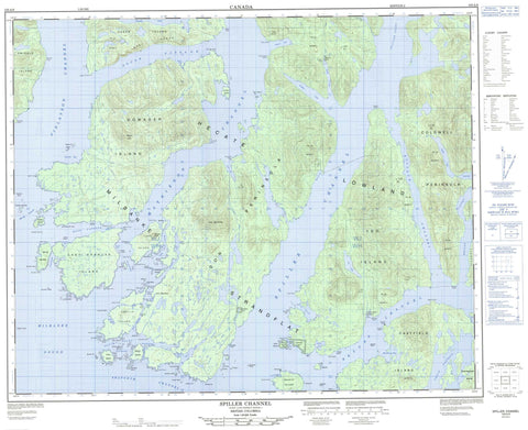
103A08 Spiller Channel Canada topo map, 1:50,000 scale
103A08 Spiller Channel NRCAN topographic map.
Includes UTM and GPS geographic coordinates (latitude and longitude). This 50k scale map is suitable for hiking, camping, and exploring, or you could frame it as a wall map.
Printed on-demand using high resolution, on heavy weight and acid free paper, or as an upgrade on a variety of synthetic materials.
Topos available on paper, Waterproof, Poly, or Tyvek. Usually shipping rolled, unless combined with other folded maps in one order.
- Product Number: NRCAN-103A08
- Parent Topo: TOPO-103A
- Map ID also known as: 103A08, 103A8
- Unfolded Size: Approximately 26" high by 36" wide
- Weight (paper map): ca. 55 grams
- Map Type: POD NRCAN Topographic Map
- Map Scale: 1:50,000
- Geographical region: British Columbia, Canada
Neighboring Maps:
All neighboring Canadian topo maps are available for sale online at 1:50,000 scale.
Purchase the smaller scale map covering this area: Topo-103A
Spatial coverage:
Topo map sheet 103A08 Spiller Channel covers the following places:
- Berry Inlet - Blair Inlet - Boat Inlet - Briggs Inlet - Bulley Bay - Bushby Bight - Cockle Bay - Emily Bay - Evening Cove - Grappler Bight - King Cove - Lambard Inlet - Morehouse Bay - Morris Bay - Mosquito Bay - Mouat Cove - Neekas Cove - Neekas Inlet - Nowish Inlet - Oliver Cove - Passage Cove - Perrin Anchorage - Port Blackney - Powell Anchorage - Salmon Bay - Spiller Inlet - Suzette Bay - Tom Bay - Wigham Cove - Yeo Cove - Agnes Point - Bailey Point - Bear Point - Bend Point - Bird Point - Boulder Head - Brew Point - Buckley Head - Bush Point - Cameron Point - Carmichael Point - Coldwell Peninsula - Coldwell Point - Cross Point - Diver Point - Don Peninsula - Donald Point - Dove Point - Early Point - Emily Peninsula - Emily Point - Ettershank Point - Ettershanks Point - Fisher Point - Florence Peninsula - Gerald Point - Grautoff Point - Graven Point - Guard Point - Hyde Point - Jermaine Point - Jorkins Point - Keith Point - Kent Point - Knarled Point - Lang Point - Legace Point - Lillie Point - McArthur Point - Miall Point - Nealon Point - Promise Point - Rankin Point - Robb Point - Salal Point - Schubert Point - Stapleton Point - Sun Point - Swindle Point - Symonds Point - Ursus Point - Balagny Passage - Bullock Channel - Clam Passage - Early Passage - Finlayson Channel - Lady Trutch Passage - Mathieson Channel - Merilia Passage - Milbanke Sound - Moss Passage - Oscar Passage - Perceval Narrows - Reid Passage - Return Channel - Seaforth Channel - Sloop Narrows - Spiller Channel - Troup Narrows - Troup Passage - Grief Island Indian Reserve 2 - Kokyet Indian Reserve 1 - Kyarti Indian Reserve 3 - Neekas Indian Reserve 4 - Réserve indienne Grief Island 2 - Réserve indienne Kokyet 1 - Réserve indienne Kyarti 3 - Réserve indienne Neekas 4 - Réserve indienne Tankeah 5 - Réserve indienne Yeo Island 13 - Tankeah Indian Reserve 5 - Yeo Island Indian Reserve 13 - Alec Islet - Arthur Island - Beak Island - Branks Islet - Canoe Island - Cecilia Island - Chatfield Island - Cunningham Island - Dakin Islets - Dallas Island - De Freitas Islets - Dearth Island - Detached Islet - Dowager Island - Evening Islets - Factor Islets - Foote Islets - Gaudin Islands - Glaholm Islet - Grief Island - Hannah Island - Harmston Island - Hay Island - Image Island - Ivory Island - Lady Douglas Island - Lake Island - Law Islands - Leighton Island - Lilly Islet - Locke Island - Lorne Islet - Martha Island - Mid Island - Nathan Island - Oke Islet - Reef Islet - Roar Islets - Salal Island - South Island - Squaw Island - Surf Islet - Susan Island - Swindle Island - Tear Islet - Walter Islet - Watch Island - Wootton Islet - Yeo Island - Cheenis Lake - Emily Lake - Tate Lagoon - Yeo Lake - Chaîne Côtière - Coast Mountains - Helmet Peak - Hyne Range - Kitimat Ranges - Lake Mountain - Mount Bell - Mount Jane - Mount Stripe - Orton Hill - Central Coast Regional District - Regional District of Kitimat-Stikine - Oliver Cove Marine Park - Neekas Creek - Neekas River - Tankeeah River - Tuno Creek - Ada Shoal - Aurelia Rock - Boulder Bank - Boulder Ledge - Bullen Rock - Carne Rock - Cod Bank - Cod Reefs - Colonel Reef - Cross Ledge - Deep Rock - Detached Rock - Diver Rock - Fellowes Rock - Flounce Reef - Holt Rock - Hyndman Reefs - Insley Rock - Joanna Rock - Kitty Patch - Lizzie Rocks - Mouse Rock - Muster Rock - Nedden Rock - Porter Reef - Rat Rock - Restless Rock - Shingle Rock - Skinner Rock


