
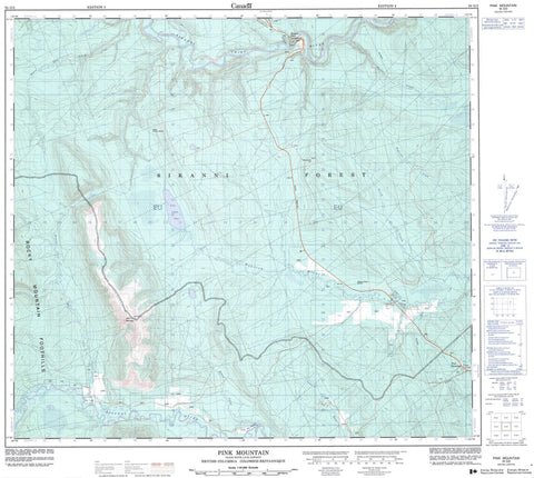
094G02 Pink Mountain Canada topo map, 1:50,000 scale
094G02 Pink Mountain NRCAN topographic map.
Includes UTM and GPS geographic coordinates (latitude and longitude). This 50k scale map is suitable for hiking, camping, and exploring, or you could frame it as a wall map.
Printed on-demand using high resolution, on heavy weight and acid free paper, or as an upgrade on a variety of synthetic materials.
Topos available on paper, Waterproof, Poly, or Tyvek. Usually shipping rolled, unless combined with other folded maps in one order.
- Product Number: NRCAN-094G02
- Parent Topo: TOPO-094G
- Map ID also known as: 094G02, 94G2, 94G02
- Unfolded Size: Approximately 26" high by 36" wide
- Weight (paper map): ca. 55 grams
- Map Type: POD NRCAN Topographic Map
- Map Scale: 1:50,000
- Geographical region: British Columbia, Canada
Neighboring Maps:
All neighboring Canadian topo maps are available for sale online at 1:50,000 scale.
Purchase the smaller scale map covering this area: Topo-094G
Spatial coverage:
Topo map sheet 094G02 Pink Mountain covers the following places:
- Lifeline Lake - Lily Lake - Pink Mountain - Rocky Mountain Foothills - Peace River Regional District - Pink Mountain Park - Peace River Lowland - Atick Creek - Barker Creek - Beatton River - Cameron River - Elbow Creek - Halfway River - Mason Creek - Moose Lick Creek - Quarter Creek - Sikanni Chief River - Two Bit Creek - Wapistan Creek - The Elbow - Beatton River - Pink Mountain - Sikanni Chief


