
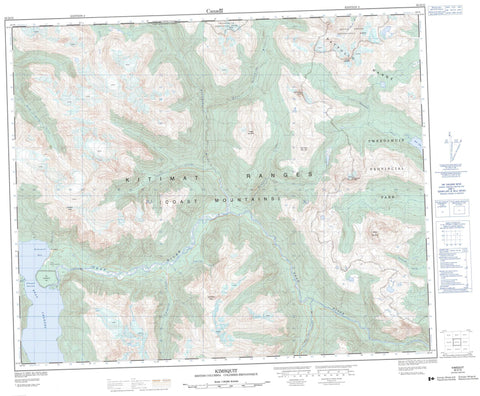
093D15 Kimsquit Canada topo map, 1:50,000 scale
093D15 Kimsquit NRCAN topographic map.
Includes UTM and GPS geographic coordinates (latitude and longitude). This 50k scale map is suitable for hiking, camping, and exploring, or you could frame it as a wall map.
Printed on-demand using high resolution, on heavy weight and acid free paper, or as an upgrade on a variety of synthetic materials.
Topos available on paper, Waterproof, Poly, or Tyvek. Usually shipping rolled, unless combined with other folded maps in one order.
- Product Number: NRCAN-093D15
- Parent Topo: TOPO-093D
- Map ID also known as: 093D15, 93D15
- Unfolded Size: Approximately 26" high by 36" wide
- Weight (paper map): ca. 55 grams
- Map Type: POD NRCAN Topographic Map
- Map Scale: 1:50,000
- Geographical region: British Columbia, Canada
Neighboring Maps:
All neighboring Canadian topo maps are available for sale online at 1:50,000 scale.
Purchase the smaller scale map covering this area: Topo-093D
Spatial coverage:
Topo map sheet 093D15 Kimsquit covers the following places:
- Kimsquit Bay - Dean Channel - Kimsquit Narrows - Sakumtha Crag - Kemsquit Indian Reserve 1 - Réserve indienne Kemsquit 1 - Stick Lake - Chaîne Côtière - Coast Mountains - Jumble Mountain - Kimsquit Peak - Kitimat Ranges - Mount Berhardt - Mount Bernhardt - Nooskulla Peak - Pattullo Range - Pisgah Mountain - Sea Lion Peak - Stick Pass Mountain - Cariboo Regional District - Central Coast Regional District - Bernhardt Creek - Bottleneck Creek - Chezko River - Dean River - East Sakumtha River - Grantham Creek - Iltasyouko River - Iltasyuko River - Kalone Creek - Kalone River - King George Creek - Manitoo Creek - Nan Creek - Nooskulla Creek - Nugleigh Creek - Sakumtha River - Salient Creek - Skuce Creek - Kimsquit


