
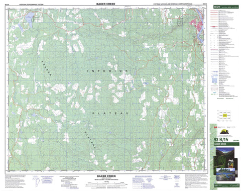
093B15 Baker Creek Canada topo map, 1:50,000 scale
093B15 Baker Creek NRCAN topographic map.
Includes UTM and GPS geographic coordinates (latitude and longitude). This 50k scale map is suitable for hiking, camping, and exploring, or you could frame it as a wall map.
Printed on-demand using high resolution, on heavy weight and acid free paper, or as an upgrade on a variety of synthetic materials.
Topos available on paper, Waterproof, Poly, or Tyvek. Usually shipping rolled, unless combined with other folded maps in one order.
- Product Number: NRCAN-093B15
- Parent Topo: TOPO-093B
- Map ID also known as: 093B15, 93B15
- Unfolded Size: Approximately 26" high by 36" wide
- Weight (paper map): ca. 55 grams
- Map Type: POD NRCAN Topographic Map
- Map Scale: 1:50,000
- Geographical region: British Columbia, Canada
Neighboring Maps:
All neighboring Canadian topo maps are available for sale online at 1:50,000 scale.
Purchase the smaller scale map covering this area: Topo-093B
Spatial coverage:
Topo map sheet 093B15 Baker Creek covers the following places:
- Quesnel - Quesnel Indian Reserve 1 - Réserve indienne Quesnel 1 - Réserve indienne Sinnce-tah-lah 2 - Sinnce-tah-lah Indian Reserve 2 - Margaret Lake - Puntchesakut Lake - Quanstrom Lake - Ruric Lake - Tiltzarone Lake - Townsend Lake - Cariboo Regional District - Pinnacles Park - Puntchesakut Lake Park - Fraser Plateau - Interior Plateau - Baker Creek - Bluestone Creek - Brailsford Creek - Chevans Creek - Cox Creek - Deserters Creek - Fleuve Fraser - Fraser River - Higdon Creek - Jordan Creek - Landslide Creek - Merston Creek - Mount Creek - Munn Creek - Narcosli Creek - Puntataenkut Creek - Puntchesakut Creek - Ruric Creek - Townsend Creek - Winnie Creek - Quesnel View


