
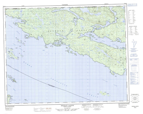
092L14 Bradley Lagoon Canada topo map, 1:50,000 scale
092L14 Bradley Lagoon NRCAN topographic map.
Includes UTM and GPS geographic coordinates (latitude and longitude). This 50k scale map is suitable for hiking, camping, and exploring, or you could frame it as a wall map.
Printed on-demand using high resolution, on heavy weight and acid free paper, or as an upgrade on a variety of synthetic materials.
Topos available on paper, Waterproof, Poly, or Tyvek. Usually shipping rolled, unless combined with other folded maps in one order.
- Product Number: NRCAN-092L14
- Parent Topo: TOPO-092L
- Map ID also known as: 092L14, 92L14
- Unfolded Size: Approximately 26" high by 36" wide
- Weight (paper map): ca. 55 grams
- Map Type: POD NRCAN Topographic Map
- Map Scale: 1:50,000
- Geographical region: British Columbia, Canada
Neighboring Maps:
All neighboring Canadian topo maps are available for sale online at 1:50,000 scale.
Purchase the smaller scale map covering this area: Topo-092L
Spatial coverage:
Topo map sheet 092L14 Bradley Lagoon covers the following places:
- Actaeon Sound - Blunden Harbour - Cohoe Bay - Collinson Bay - Creasy Bay - Davis Bay - Deer Cove - Drury Inlet - Hand Bay - Jennis Bay - Kenneth Bay - Lewis Cove - Macgowan Bay - Marsh Bay - Shelter Bay - Skeene Bay - Sutherland Bay - Tancred Bay - Akam Point - Aylmer Point - Bartlett Point - Bedwell Point - Blackney Point - Bond Peninsula - Boone Point - Boyles Point - Brandon Point - Byron Point - Castle Point - Charlotte Point - Charters Point - Cunningham Point - Duval Point - Edgell Point - England Point - Howcraft Point - O'Keefe Point - Shelf Head - Shelf Point - Shuckburgh Point - Skeene Point - Stuart Point - Taylor Point - Tomlinson Point - Westcott Point - Actress Passage - Goletas Channel - Labouchere Passage - Queen Charlotte Strait - Richards Channel - Ripple Passage - Dove Island Indian Reserve 12 - Gleyka Indian Reserve 6 - Kwetahkis Indian Reserve 9 - Mahpahkum Indian Reserve 4 - Pahas Indian Reserve 3 - Réserve indienne Dove Island 12 - Réserve indienne Gleyka 6 - Réserve indienne Kwetahkis 9 - Réserve indienne Mahpahkum 4 - Réserve indienne Pahas 3 - Augustine Islands - Barry Islet - Browning Islands - Burgess Island - Byrnes Island - Davis Islet - Deserters Group - Deserters Island - Dove Island - Doyle Island - Duval Island - Echo Islands - Edgell Island - Everard Islands - Everard Islets - Frost Islands - Ghost Island - Gordon Group - Gordon Islands - Grave Island - Grave Islet - Gregory Island - Gregory Islet - Hooper Island - Jeannette Islands - Jenkins Islet - Jula Island - Keith Islet - Keith Islets - Masterman Islands - McLeod Island - Millar Group - Muirhead Islands - Nankivell Islands - Numas Islands - Raynor Group - Richard Islets - Robertson Island - Robinson Island - Snell Islet - Staples Islet - Staples Islets - Twin Islands - Vancouver Island - Wallace Islands - Wilson Island - Wishart Island - Adelaide Lake - Bamford Lagoon - Bond Lagoon - Bowman Lake - Bradley Lagoon - Burnett Lake - Cairie Lake - Creasy Lake - Despard Lake - Ellen Lake - Huaskin Lake - Irvine Lake - Lee Lake - Lottie Lake - Lower Lagoon - Marion Lake - McKinnon Lagoon - Nenahlmai Lagoon - Parnell Lake - Portage Lake - Quick Lake - Royal Lake - Sea Lion Lake - Shoal Lake - Strong Lake - Tsibass Lagoon - Upper Lagoon - Viola Lake - Whelakis Lagoon - Yoder Lake - Amies Hill - Aylen Hill - Coast Hill - Coast Mountains - Farmer Hill - Herbert Peak - Leading Hill - Miles Cone - Mount Adams - Mount Amies - Mount Bullock - Mount Ellis - Mount Gardiner - Mount Hulme - Mount Kerr - Mount Russell - Mount Ward - Mount Wynyard - Pacific Ranges - Robinson Range - Russell Hill - Silverlock Hills - Regional District of Mount Waddington - Cohoe Creek - Kenneth River - Annie Rocks - Barren Rock - Blount Rock - Brandon Rock - Centre Rock - David Rock - Echo Rock - Ellinor Rock - Gillot Rock - Lewis Rocks - Mary Rock - Moore Rock - Morgan Shoal - Siwiti Rock - Stuart Rock - Taylor Bank - Willoughby Rocks


