
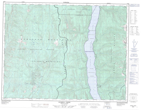
082E09 Burrell Creek Canada topo map, 1:50,000 scale
082E09 Burrell Creek NRCAN topographic map.
Includes UTM and GPS geographic coordinates (latitude and longitude). This 50k scale map is suitable for hiking, camping, and exploring, or you could frame it as a wall map.
Printed on-demand using high resolution, on heavy weight and acid free paper, or as an upgrade on a variety of synthetic materials.
Topos available on paper, Waterproof, Poly, or Tyvek. Usually shipping rolled, unless combined with other folded maps in one order.
- Product Number: NRCAN-082E09
- Parent Topo: TOPO-082E
- Map ID also known as: 082E09, 82E9, 82E09
- Unfolded Size: Approximately 26" high by 36" wide
- Weight (paper map): ca. 55 grams
- Map Type: POD NRCAN Topographic Map
- Map Scale: 1:50,000
- Geographical region: British Columbia, Canada
Neighboring Maps:
All neighboring Canadian topo maps are available for sale online at 1:50,000 scale.
Purchase the smaller scale map covering this area: Topo-082E
Spatial coverage:
Topo map sheet 082E09 Burrell Creek covers the following places:
- Bowman Falls - Bear Paw Lake - Cinnamon Lake - Lily Pad Lake - Lower Arrow Lake - Christina Range - Columbia Mountains - Franklin Mountain - Midway Mountains - Midway Range - Monashee Mountains - Mount Franklin - Mount McKinley - Mount O'Leary - Mount Sloan - Sangrida Peak - Selkirk Mountains - Tenderloin Mountain - Valhalla Mountains - Valhalla Range - Valhalla Ranges - Valkyr Mountains - Valkyr Range - Regional District of Kootenay-Boundary - Granby Park - Bluejoint Creek - Bowman Creek - Burrell Creek - Cane Creek - Cinnamon Creek - Columbia River - Dane Creek - Deer Creek - Dinsmore Creek - Eclipse Creek - Fleuve Columbia - Franklin Creek - Gladstone Creek - Gloucester Creek - Granby River - Howe Creek - Hutchison Creek - I X L Creek - Johnston Creek - Last Chance Creek - McFarlane Creek - Michaud Creek - Molly Creek - Nicoll Creek - North Cinnamon Creek - Octopus Creek - Philippa Creek - Pinto Creek - Sangrida Creek - Smith Creek - Sunshine Creek - Twin Creek - Twobit Creek - Two-bit Creek - Van Houten Creek - Walter Creek - Worthington Creek


