Free Shipping on map orders over $300
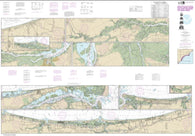
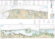
Intracoastal Waterway Fort Myers to Charlotte Harbor and Wiggins Pass (11427-35) by NOAA
Intracoastal Waterway Galveston Bay to Cedar Lakes (11322-33) by NOAA
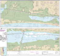
Intracoastal Waterway Laguna Madre - Chubby Island to Stover Point, including The Arroyo Colorado (11303-22) by NOAA
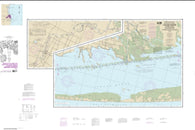
Intracoastal Waterway Laguna Madre Middle Ground to Chubby Island (11306-22) by NOAA
Intracoastal Waterway Lake Wimico to East Bay (11393-22) by NOAA
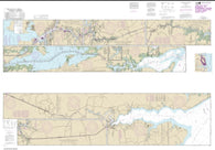
Intracoastal Waterway Little Egg Harbor to Cape May; Atlantic City (12316-35) by NOAA
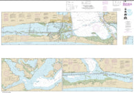
Intracoastal Waterway Matecumbe to Grassy Key (11449-17) by NOAA
Intracoastal Waterway Miami to Elliot Key (11465-39) by NOAA
Intracoastal Waterway Morgan City to Port Allen, including the Atchafalaya River (11354-28) by NOAA
Intracoastal Waterway Myrtle Grove Sound and Cape Fear River to Casino Creek (11534-38) by NOAA
Intracoastal Waterway Neuse River to Myrtle Grove Sound (11541-40) by NOAA
Intracoastal Waterway New Orleans to Calcasieu River East Section (11352-42) by NOAA
Intracoastal Waterway New Orleans to Calcasieu River West Section (11345-35) by NOAA
Intracoastal Waterway Norfolk to Albemarle Sound via North Landing River or Great Dismal Swamp Canal (12206-34) by NOAA
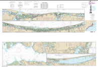
Intracoastal Waterway Palm Shores to West Palm Beach; Loxahatchee River (11472-36) by NOAA
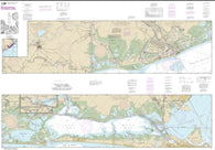
Intracoastal Waterway Redfish Bay to Middle Ground (11308-25) by NOAA
Intracoastal Waterway Sands Key to Blackwater Sound (11463-19) by NOAA
Intracoastal Waterway Sandy Hook to Little Egg Harbor (12324-35) by NOAA
Intracoastal Waterway Santa Rosa Sound to Dauphin Island (11378-38) by NOAA
Intracoastal Waterway St. Simons Sound to Tolomato River (11489-40) by NOAA
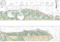
Intracoastal Waterway Stover Point to Port Brownsville, including Brazos Santiago Pass (11302-34) by NOAA
Intracoastal Waterway Sugarloaf Key To Key West (11446-33) by NOAA
Intracoastal Waterway Tampa Bay to Port Richey (11411-19) by NOAA
Intracoastal Waterway Tolomato River to Palm Shores (11485-37) by NOAA
Intracoastal Waterway Waveland to Catahoula Bay (11367-37) by NOAA
Intracoastal Waterway Wax Lake Outlet to Forked Island including Bayou Teche, Vermilion River, and Freshwater Bayou (11350-28) by NOAA
Intracoastal Waterway West Bay to Santa Rosa Sound (11385-28) by NOAA
Intracoastal Waterway West Palm Beach to Miami (11467-43) by NOAA
Inukjuak et les Approches and Approaches by Canadian Hydrographic Service
Inyo National Forest Map
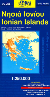
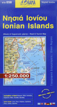
Ionian Islands : road / tourist & navy map 1:250.000 : / & 1:250.000
Ionian Islands, Greece by Orama Editions
Ios Island Map
Ios, Greece by Road Editions
Iowa : Easy to Read : Folded Map
Iowa Atlas and Gazetteer
Iowa Atlas and Gazetteer by DeLorme
Iowa by Kappa Map Group
Iowa by Rand McNally
Iowa State Map