Free Shipping on map orders over $300
Appalachian Trail wall map : laminated
Appalachian Trail Wall Map, Boxed by National Geographic Maps
Appalachian Trail [Map Pack Bundle]
Appalachian Trail, Laminated, Polybagged by National Geographic Maps
Appalachian Trail: Georgia, North Carolina, Tennessee [Map Pack Bundle]
Appalachian Trail: Maine [Map Pack Bundle]
Appalachian Trail: Pennsylvania [Map Pack Bundle]
Appalachian Trail: Vermont, New Hampshire [Map Pack Bundle]
Appalachian Trail: Virginia, West Virginia, Maryland [Map Pack Bundle]
Appenzellerland St. Gallen - Santis Hiking Map
Appleton and the Fox Cities, Wisconsin by The Seeger Map Company Inc.
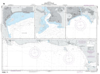
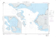
Approach To Port-Au-Prince (NGA-26184-4) by National Geospatial-Intelligence Agency
Approach to/Approches a Sorry Harbor by Canadian Hydrographic Service
Approaches To Acajutla And La Libertad (NGA-21524-3) by National Geospatial-Intelligence Agency
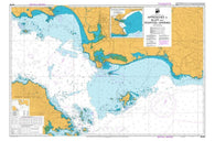
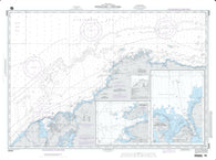
Approaches to Admiralty Inlet Dungeness to Oak Bay (18471-11) by NOAA
Approaches To Andres, San Pedro De Macoris And La Romana (NGA-25849-13) by National Geospatial-Intelligence Agency
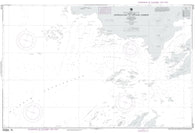
APPROACHES TO APIA (865) by Land Information New Zealand (LINZ)
Approaches To Arthur Harbor (NGA-29126-2) by National Geospatial-Intelligence Agency
APPROACHES TO AUCKLAND (NZ532) by Land Information New Zealand (LINZ)
Approaches To Bahia De Samana (NGA-25723-40) by National Geospatial-Intelligence Agency
Approaches To Balboa (NGA-21603-10) by National Geospatial-Intelligence Agency
Approaches To Barahona And Punta Palenque (NGA-25842-10) by National Geospatial-Intelligence Agency
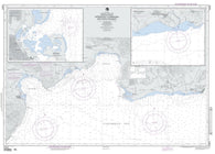
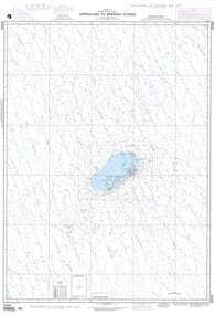
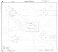
Approaches To Bermuda Islands (NGA-26340-5) by National Geospatial-Intelligence Agency
Approaches To Bikini Atoll (Marshall Islands) (NGA-81540-2) by National Geospatial-Intelligence Agency
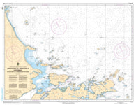
Approaches to Blue Hill Bay (13313-21) by NOAA
APPROACHES TO BLUFF AND RIVERTON/APARIMA (681) by Land Information New Zealand (LINZ)
Approaches To Bocas Del Toro And Laguna De Chiriqui (NGA-28041-4) by National Geospatial-Intelligence Agency
Approaches To Cabo Rojo And Pedernales (NGA-25841-9) by National Geospatial-Intelligence Agency
Approaches To Cap-Haitien And Bahia De Monte Cristi (NGA-26142-10) by National Geospatial-Intelligence Agency
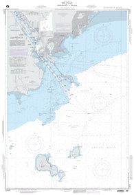
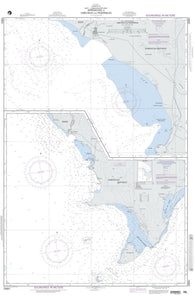
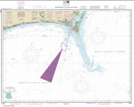
Approaches to Cape Fear River (11536-20) by NOAA
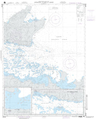
Approaches to Cartwright, Balck Island to Tumbledown Dick Island by Canadian Hydrographic Service
Approaches To Champerico (NGA-21490-1) by National Geospatial-Intelligence Agency
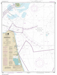
Approaches to Chesapeake Bay (12208-16) by NOAA
Approaches To Cristobal (NGA-26066-13) by National Geospatial-Intelligence Agency
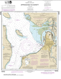
Approaches to Everett (18443-17) by NOAA
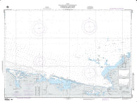
Approaches to Galveston Bay (11323-65) by NOAA
Approaches to Hamilton Inlet, Tumbledown Dick Island to Quaker Hat by Canadian Hydrographic Service
Approaches To Kampong Saom (NGA-93284-5) by National Geospatial-Intelligence Agency
Approaches To La Ceiba (NGA-28154-2) by National Geospatial-Intelligence Agency
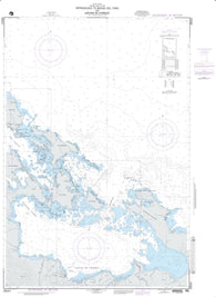
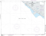
Approaches to Lahaina, Island of Maui (19348-8) by NOAA


![Buy map Appalachian Trail [Map Pack Bundle]](http://store.yellowmaps.com/cdn/shop/products/TI_APPALACHIAN_TRL_BUNDLE_21_large_d35d96a2-f894-44cb-97f1-ee08f4f2964f_195x.jpg?v=1706907142)

![Buy map Appalachian Trail: Georgia, North Carolina, Tennessee [Map Pack Bundle]](http://store.yellowmaps.com/cdn/shop/products/TI_APPALACHIAN_TRLS_BUNDLE_21_large_eee80324-466d-4c76-82bc-96f8417d7a2a_195x.jpg?v=1706907127)
![Buy map Appalachian Trail: Maine [Map Pack Bundle]](http://store.yellowmaps.com/cdn/shop/products/TI_APP_TRLS_ME_PK_20_large_923e0ec1-8b4b-4c90-a3ac-f551dc8ae959_195x.jpg?v=1706907130)
![Buy map Appalachian Trail: Pennsylvania [Map Pack Bundle]](http://store.yellowmaps.com/cdn/shop/products/TI_APP_TRLS_PA_PK_21_large_2b7bd220-a817-4b15-b3d0-4ce402ab133a_195x.jpg?v=1706907133)
![Buy map Appalachian Trail: Vermont, New Hampshire [Map Pack Bundle]](http://store.yellowmaps.com/cdn/shop/products/TI_APP_TRLS_VT_NH_PK_20_large_828fff9b-f447-4c98-ab65-e2510e7d650c_195x.jpg?v=1706907139)
![Buy map Appalachian Trail: Virginia, West Virginia, Maryland [Map Pack Bundle]](http://store.yellowmaps.com/cdn/shop/products/TI_APP_TRLS_VA_WV_MD_PK_21_large_e6830f45-d5ef-46fd-b948-0d1cc248366e_195x.jpg?v=1706907136)