
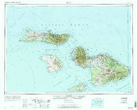
~ Maui HI topo map, 1:250000 scale, 1 X 2 Degree, Historical, 1974, updated 1974
Maui, Hawaii, USGS topographic map dated 1974.
Includes geographic coordinates (latitude and longitude). This topographic map is suitable for hiking, camping, and exploring, or framing it as a wall map.
Printed on-demand using high resolution imagery, on heavy weight and acid free paper, or alternatively on a variety of synthetic materials.
Topos available on paper, Waterproof, Poly, or Tyvek. Usually shipping rolled, unless combined with other folded maps in one order.
- Product Number: USGS-5644746
- Free digital map download (high-resolution, GeoPDF): Maui, Hawaii (file size: 15 MB)
- Map Size: please refer to the dimensions of the GeoPDF map above
- Weight (paper map): ca. 55 grams
- Map Type: POD USGS Topographic Map
- Map Series: HTMC
- Map Verison: Historical
- Cell ID: 68896
- Scan ID: 349931
- Imprint Year: 1974
- Woodland Tint: Yes
- Field Check Year: 1961
- Datum: Unstated
- Map Projection: Transverse Mercator
- Map published by United States Geological Survey
- Map published by United States Army Corps of Engineers
- Map published by United States Army
- Map Language: English
- Scanner Resolution: 600 dpi
- Map Cell Name: Maui
- Grid size: 1 X 2 Degree
- Date on map: 1974
- Map Scale: 1:250000
- Geographical region: Hawaii, United States
Neighboring Maps:
All neighboring USGS topo maps are available for sale online at a variety of scales.
Spatial coverage:
Topo map Maui, Hawaii, covers the geographical area associated the following places:
- Hālena - Kamiloloa - Nāhiku - Māla - Keoneʻōʻio - Kepuhi - Waiehu - Ranch Camp (historical) - Keomuku (historical) - Airport Village (historical) - Kōheo - Kaupakulua - Hāmoa - Mahana (historical) - ʻUlaʻino (historical) - Crater Village - Oloewa (historical) - Village Thirteen (historical) - Narushi Camp (historical) - Lalakoa - Mūʻolea - Kualapuʻu - Māʻalaea - Village Six (historical) - Hālawa - Kaʻiliʻili (historical) - Hāmākuapoko (historical) - Nuʻu (historical) - Pauwalu - Paako - Waiakoa - School Village (historical) - Kaunakakai - Paholoi (historical) - Paukūkalo - Peahi (historical) - Kapalua - Kūʻau - McGerrow Village (historical) - Yung Hee Village (historical) - Kamalō - Pukaauhuhu - Moʻomomi - Lopa - Japanese Village One (historical) - Puʻuiki - Waiheʻe - Kahakuloa - Kīpahulu - Hāʻōʻū - Hoʻolehua - Waineʻe - Wailea - Pūlehu - Waikapū - Honokōhau - Kāʻanapali - Kahului - Hyashi Village (historical) - Kaʻonoʻulu (historical) - Otani Camp (historical) - Sam Sing Village (historical) - Kaumalapau - Kāheka Village (historical) - Kawela - Hōkūʻula - Mokulau - Kaluaʻaha - Puʻunēnē - Puʻuohala Village - Lower Village Three (historical) - Village Two (historical) - ʻUalapuʻe - Huelo - Maunaloa - Upper Nahiku - Hawaiian-Spanish Village (historical) - Upper Village Three - Village Five (historical) - Maui Meadows - Manila Camp (historical) - Waialua - Russian Village (historical) - Kalaupapa - Puunoa - Happy Valley - Olinda - Lahainaluna - Onau (historical) - Kailua - Launiupoko - Alabama Village (historical) - Cod Fish Village (historical) - Wahīlauhue - ʻUlupalakua - Waiehu Camp - Kalawao - Ah Fong Village (historical) - Koele (historical) - Maʻālehu
- Map Area ID: AREA21.520.5-157.5-155.9666667
- Northwest corner Lat/Long code: USGSNW21.5-157.5
- Northeast corner Lat/Long code: USGSNE21.5-155.9666667
- Southwest corner Lat/Long code: USGSSW20.5-157.5
- Southeast corner Lat/Long code: USGSSE20.5-155.9666667
- Northern map edge Latitude: 21.5
- Southern map edge Latitude: 20.5
- Western map edge Longitude: -157.5
- Eastern map edge Longitude: -155.9666667


