
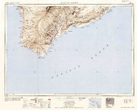
~ Hawaii South HI topo map, 1:250000 scale, 1 X 2 Degree, Historical, 1954, updated 1954
Hawaii South, Hawaii, USGS topographic map dated 1954.
Includes geographic coordinates (latitude and longitude). This topographic map is suitable for hiking, camping, and exploring, or framing it as a wall map.
Printed on-demand using high resolution imagery, on heavy weight and acid free paper, or alternatively on a variety of synthetic materials.
Topos available on paper, Waterproof, Poly, or Tyvek. Usually shipping rolled, unless combined with other folded maps in one order.
- Product Number: USGS-5644728
- Free digital map download (high-resolution, GeoPDF): Hawaii South, Hawaii (file size: 16 MB)
- Map Size: please refer to the dimensions of the GeoPDF map above
- Weight (paper map): ca. 55 grams
- Map Type: POD USGS Topographic Map
- Map Series: HTMC
- Map Verison: Historical
- Cell ID: 68821
- Scan ID: 349922
- Imprint Year: 1954
- Datum: Unstated
- Map Projection: Transverse Mercator
- Map published by United States Geological Survey
- Map published by United States Army Corps of Engineers
- Map published by United States Army
- Map Language: English
- Scanner Resolution: 600 dpi
- Map Cell Name: Hawaii South
- Grid size: 1 X 2 Degree
- Date on map: 1954
- Map Scale: 1:250000
- Geographical region: Hawaii, United States
Neighboring Maps:
All neighboring USGS topo maps are available for sale online at a variety of scales.
Spatial coverage:
Topo map Hawaii South, Hawaii, covers the geographical area associated the following places:
- Keālia - Hīlea - Ohaikea (historical) - Okoe (historical) - Kaueleau - Fern Forest - Lae ʻApuki (historical) - Kaimū - Kaunēnē - Manukā (historical) - Pohoiki - ʻAinapō - Volcano - Punaluʻu - Glenwood - Keanapaʻakai (historical) - Hawaiian Ocean View - Punaluu Kahawai - Nāʻālehu - Niuʻoʻu (historical) - Pāhala - Leilani Estates - Olelomoana (historical) - Napoʻopoʻo - Country Garden Estates - Pāpā (historical) - Waiʻōhinu - Kalapana (historical) - Miloliʻi - ʻĀpua (historical) - Kaʻawaloa - Eden Roc - Kona South Estates - Kapaahu - Kalapana Sea View Estates - Hawaiian Ocean View Estates - Kehena - Kealakomo (historical) - Discovery Harbour - Captain Cook - Pualaa - Honuʻapo - Pāpā Bay Estates - Kēōkea - Napumaia (historical) - Hawaiian Ocean View Ranchos - Moaula (historical) - Hōnaunau - Royal Gardens (historical) - Keʻei - Ohaikea Houses (historical) - Vacationland Hawaii - Kipuka Nahuaopala (historical) - Nīnole - Waikapuna - Kapuʻa (historical) - Kaniahiku Village - Komakawai - Pāhoa - Hoʻōpūloa - Hoʻokena - Opihikao
- Map Area ID: AREA19.518.5-156.0833333-154.5833333
- Northwest corner Lat/Long code: USGSNW19.5-156.0833333
- Northeast corner Lat/Long code: USGSNE19.5-154.5833333
- Southwest corner Lat/Long code: USGSSW18.5-156.0833333
- Southeast corner Lat/Long code: USGSSE18.5-154.5833333
- Northern map edge Latitude: 19.5
- Southern map edge Latitude: 18.5
- Western map edge Longitude: -156.0833333
- Eastern map edge Longitude: -154.5833333


