
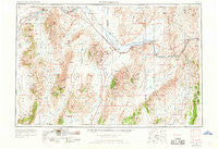
~ Winnemucca NV topo map, 1:250000 scale, 1 X 2 Degree, Historical, 1955, updated 1968
Winnemucca, Nevada, USGS topographic map dated 1955.
Includes geographic coordinates (latitude and longitude). This topographic map is suitable for hiking, camping, and exploring, or framing it as a wall map.
Printed on-demand using high resolution imagery, on heavy weight and acid free paper, or alternatively on a variety of synthetic materials.
Topos available on paper, Waterproof, Poly, or Tyvek. Usually shipping rolled, unless combined with other folded maps in one order.
- Product Number: USGS-5573912
- Free digital map download (high-resolution, GeoPDF): Winnemucca, Nevada (file size: 20 MB)
- Map Size: please refer to the dimensions of the GeoPDF map above
- Weight (paper map): ca. 55 grams
- Map Type: POD USGS Topographic Map
- Map Series: HTMC
- Map Verison: Historical
- Cell ID: 69104
- Scan ID: 321808
- Imprint Year: 1968
- Woodland Tint: Yes
- Edit Year: 1962
- Datum: Unstated
- Map Projection: Transverse Mercator
- Map published by United States Geological Survey
- Map published by United States Army Corps of Engineers
- Map published by United States Army
- Map Language: English
- Scanner Resolution: 600 dpi
- Map Cell Name: Winnemucca
- Grid size: 1 X 2 Degree
- Date on map: 1955
- Map Scale: 1:250000
- Geographical region: Nevada, United States
Neighboring Maps:
All neighboring USGS topo maps are available for sale online at a variety of scales.
Spatial coverage:
Topo map Winnemucca, Nevada, covers the geographical area associated the following places:
- Telluride (historical) - Argenta - Knight - Cherry Creek (historical) - Leeville - Kennedy (historical) - Cortez - Mud Springs (historical) - Beowawe - Tonka - Kyle Hot Springs - Galena (historical) - Cluro - Red House - Rose Creek - Dewitt Mill - Hilltop - Rosny - Kampos - Vivian - Shoshone - Rixies - Carlin - Palisade - Bullion (historical) - Alpha - Fairview (historical) - Mineral - Gold Quartz - Tyrol - Winnemucca - Herrin - Gold Run (historical) - Raglan - Starr (historical) - Dean (historical) - Bannock - Buckhorn - Betty O'Neal (historical) - Barth - Pittsburgh (historical) - Piute - Frisbie (historical) - Crescent Valley - Copper Basin - Gold Acres - Buckingham Camp - Thomas Place - Gerald (historical) - Bonnie Briar (historical) - Preble - Middletown (historical) - Primeaux - Blanco (historical) - Old Battle Mountain (historical) - Dun Glen (historical) - Mosel - McCoy - Mill Gulch (historical) - Golconda - Lander (historical) - Blackburn - Jenkins - Bailey (historical) - Rennox - Stone House (historical) - Goldville (historical) - Valmy - Battle Mountain - Shannon - Maysville (historical) - Jersey (historical) - Tenabo - Harney - Dunphy - North Battle Mountain - Adelaide (historical) - Iron Point (historical) - Ellison
- Map Area ID: AREA4140-118-116
- Northwest corner Lat/Long code: USGSNW41-118
- Northeast corner Lat/Long code: USGSNE41-116
- Southwest corner Lat/Long code: USGSSW40-118
- Southeast corner Lat/Long code: USGSSE40-116
- Northern map edge Latitude: 41
- Southern map edge Latitude: 40
- Western map edge Longitude: -118
- Eastern map edge Longitude: -116


