
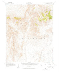
~ Topopah Spring NV topo map, 1:62500 scale, 15 X 15 Minute, Historical, 1952
Topopah Spring, Nevada, USGS topographic map dated 1952.
Includes geographic coordinates (latitude and longitude). This topographic map is suitable for hiking, camping, and exploring, or framing it as a wall map.
Printed on-demand using high resolution imagery, on heavy weight and acid free paper, or alternatively on a variety of synthetic materials.
Topos available on paper, Waterproof, Poly, or Tyvek. Usually shipping rolled, unless combined with other folded maps in one order.
- Product Number: USGS-5573288
- Free digital map download (high-resolution, GeoPDF): Topopah Spring, Nevada (file size: 8 MB)
- Map Size: please refer to the dimensions of the GeoPDF map above
- Weight (paper map): ca. 55 grams
- Map Type: POD USGS Topographic Map
- Map Series: HTMC
- Map Verison: Historical
- Cell ID: 63632
- Scan ID: 321374
- Woodland Tint: Yes
- Aerial Photo Year: 1952
- Field Check Year: 1952
- Datum: NAD27
- Map Projection: Polyconic
- Map published by United States Geological Survey
- Map published by United States Army Corps of Engineers
- Map published by United States Army
- Map Language: English
- Scanner Resolution: 600 dpi
- Map Cell Name: Topopah Spring
- Grid size: 15 X 15 Minute
- Date on map: 1952
- Map Scale: 1:62500
- Geographical region: Nevada, United States
Neighboring Maps:
All neighboring USGS topo maps are available for sale online at a variety of scales.
Spatial coverage:
Topo map Topopah Spring, Nevada, covers the geographical area associated the following places:
- Castle Point - Teacup Wash - Well J-Twelve - Yucca Mountain - Pagany Wash - Jackass Flats - West Ridge - Claim Canyon - Shoshone Jeep Trail - Boundary Ridge - Busted Butte - Knotted Ridge - Tiva Canyon - Vent Pass - Comb Peak - Delirium Canyon - Stairs Ridge - The Prow - Quartz Mountain Camp (historical) - Shoshone Peak - Bow Ridge - Quail Ridge - Yucca Wash - Lithic Ridge - Jet Ridge - Alice Point - Castellated Ridge - Chukar Canyon - Ambush Pass - Iron Ridge - Sever Wash - Jackass Flats Branch Post Office (historical) - Weather Tower Station 14 - Topopah Spring - Twin Springs - Dune Wash - Three Forks Wash - Pinnacles Ridge - Yucca Crest - Joey Ridge - Paintbrush Canyon - Creosote Ridge - Sear Valley - Boundary Butte - Chocolate Mountain - Plug Hill - Black Glass Canyon - Nevada Test Site Area 400 - Jake Ridge - Prow Pass - Isolation Ridge - Fran Ridge - Water Pipe Butte - Pah Canyon - Little Prow - False Crest - Pinyon Pass - Nevada Test Site - Iron Tank - Fortymile Canyon - Solitario Canyon - Dome Mountain
- Map Area ID: AREA3736.75-116.5-116.25
- Northwest corner Lat/Long code: USGSNW37-116.5
- Northeast corner Lat/Long code: USGSNE37-116.25
- Southwest corner Lat/Long code: USGSSW36.75-116.5
- Southeast corner Lat/Long code: USGSSE36.75-116.25
- Northern map edge Latitude: 37
- Southern map edge Latitude: 36.75
- Western map edge Longitude: -116.5
- Eastern map edge Longitude: -116.25


