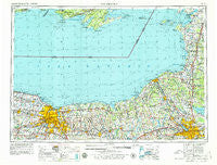
~ Rochester NY topo map, 1:250000 scale, 1 X 2 Degree, Historical, 1961, updated 1979
Rochester, New York, USGS topographic map dated 1961.
Includes geographic coordinates (latitude and longitude). This topographic map is suitable for hiking, camping, and exploring, or framing it as a wall map.
Printed on-demand using high resolution imagery, on heavy weight and acid free paper, or alternatively on a variety of synthetic materials.
Topos available on paper, Waterproof, Poly, or Tyvek. Usually shipping rolled, unless combined with other folded maps in one order.
- Product Number: USGS-5454899
- Free digital map download (high-resolution, GeoPDF): Rochester, New York (file size: 18 MB)
- Map Size: please refer to the dimensions of the GeoPDF map above
- Weight (paper map): ca. 55 grams
- Map Type: POD USGS Topographic Map
- Map Series: HTMC
- Map Verison: Historical
- Cell ID: 68989
- Scan ID: 136526
- Imprint Year: 1979
- Woodland Tint: Yes
- Visual Version Number: 1
- Aerial Photo Year: 1977
- Edit Year: 1978
- Field Check Year: 1961
- Datum: Unstated
- Map Projection: Transverse Mercator
- Map published by United States Geological Survey
- Map Language: English
- Scanner Resolution: 600 dpi
- Map Cell Name: Rochester
- Grid size: 1 X 2 Degree
- Date on map: 1961
- Map Scale: 1:250000
- Geographical region: New York, United States
Neighboring Maps:
All neighboring USGS topo maps are available for sale online at a variety of scales.
Spatial coverage:
Topo map Rochester, New York, covers the geographical area associated the following places:
- Clarkson - Harper Park - Lyndon Lawns Mobile Home Park - Jones Corners - Foland Trailer Park - Montario Point - Lacona - North Hamlin - Sunset Valley Manufactured Home Community - Cliffside Trailer Park - Lakeside - North Port Byron - Jewettville - Saxe Corner - Demster Beach - Fawn Estates Mobile Home Park - Westvale - Cicero - North Rush - Winter Mobile Home Park - Stone Church - Mount Pleasant - High Bridge - North Wolcott - Camillus - Lyncourt - Tylers Corner - Adams - Westview Manor - Little France - Bennetts Corners - Ontario - Troutburg - Bailey - Indian Hills Mobile Home Park - Rochester - Split Rock - Suttons Corner - Rice Mill - Liberty Park Mobile Home Park - Franklin Park - West Walworth - Partridge Acres Mobile Home Park - Radisson - Bethel Corners - Windcrest Park - Baird Corners - Vienna Estates - Island Cottage Beach - Valley View Mobile Home Park - Manns Corner - Victory - Willow Grove - Alloway - South Granby - Greece - Zurich - Forest Beach - Onondaga Hill - Five Points - North Scriba - West Genesee Terrace - Gilbert Mills - Resort - Lyndon - Albion Center - Windsor Beach - Mud Mills - Bowens Corners - Lemoyne Mobile Home Park - West Shore Mobile Home Park - Riga - Benedict Beach - Williamson - Huron - South New Haven - Whig Hill - Lower South Bay - East Bergen - Lincoln Park - Sandy Bay - Brennan Beach Mobile Home Park - Jefferson Park - Kerfien's Mobile Home Park - Orchard Mobile Home Park - Summerhill Village Mobile Home Park - York - Braddock Heights - Chezwick Estates Mobile Home Park - Casual Estates - Wautoma Beach - Lamson - Mannsville - Hamlin - Egypt - Kendall Mills - Hickory Grove - Thompson - Hidden Valley Mobile Home Park - Kellys Corners
- Map Area ID: AREA4443-78-76
- Northwest corner Lat/Long code: USGSNW44-78
- Northeast corner Lat/Long code: USGSNE44-76
- Southwest corner Lat/Long code: USGSSW43-78
- Southeast corner Lat/Long code: USGSSE43-76
- Northern map edge Latitude: 44
- Southern map edge Latitude: 43
- Western map edge Longitude: -78
- Eastern map edge Longitude: -76

