
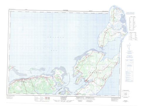
021P15 Caraquet Canada topo map, 1:50,000 scale
021P15 Caraquet NRCAN topographic map.
Includes UTM and GPS geographic coordinates (latitude and longitude). This 50k scale map is suitable for hiking, camping, and exploring, or you could frame it as a wall map.
Printed on-demand using high resolution, on heavy weight and acid free paper, or as an upgrade on a variety of synthetic materials.
Topos available on paper, Waterproof, Poly, or Tyvek. Usually shipping rolled, unless combined with other folded maps in one order.
- Product Number: NRCAN-021P15
- Parent Topo: TOPO-021P
- Map ID also known as: 021P15, 21P15
- Unfolded Size: Approximately 26" high by 36" wide
- Weight (paper map): ca. 55 grams
- Map Type: POD NRCAN Topographic Map
- Map Scale: 1:50,000
- Geographical region: New Brunswick, Canada
Neighboring Maps:
All neighboring Canadian topo maps are available for sale online at 1:50,000 scale.
Purchase the smaller scale map covering this area: Topo-021P
Spatial coverage:
Topo map sheet 021P15 Caraquet covers the following places:
- Baie Brûlé - Baie de Caraquet - Baie de Chaleur - Baie de Lamèque - Baie de Petite-Lamèque - Baie de Shippegan - Baie des Chaleurs - Baie Saint-Simon-Nord - Basse Bay - Caraquet Bay - Caraquet Harbour - Caribou Cove - Chaleur Bay - Golfe du Saint-Laurent - Golfe Saint-Laurent - Gulf of St. Lawrence - Lamek Bay - Miscou Harbour - North St. Simon Inlet - Portage Bay - Ruisseau Jean-Marie - Saint-Simon Inlet - Shippegan Harbour - Shippigan Harbour - St. Simon Inlet - Dune de Maisonnette - Fox Dens Beach - Grande Batture - La Dune - Miscou Beach - Pigeon Hill Bar - Benlays Point - Black Point - Campbells Point - Cap Bateau - Harper Point - Herring Point - Indian Point - Maisonnette Point - Marks Point - Mya Point - Paint Point - Pandora Point - Pecten Point - Petit Cap - Pointe à Baleine - Pointe à Bernache - Pointe à Brideau - Pointe à l'Église - Pointe à Mailloux - Pointe à Marcelle - Pointe à Peinture - Pointe Alexandre - Pointe Barachois - Pointe Brûlé - Pointe Canot - Pointe de Lamèque - Pointe de Maisonnette - Pointe de Petite-Lamèque - Pointe de Petit-Lamèque - Pointe de Pokesudie - Pointe de Pruce - Pointe de Pruche - Pointe de Roche - Pointe des Blanchard - Pointe d'Herbe - Pointe du Nord-Ouest - Pointe Légère - Pokesudi Point - Pokesudie Point - Sandy Point - Sandy Point - Sandy Point - Skait Point - Stoke Point - Caraquet Channel - Fisherman Channel - Fox Dens Gully - Miscou Channel - Petite Passe - Shippegan Channel - Shippegan Sound - Caraquet - Gloucester - New Bandon - Shippegan - Caraquet Island - Île au Cheval - Ile au Trésor - Île de Caraquet - Île Lamèque - Île Miscou - Île Pokesudie - L'Îlette de Pokesudie - Little Pokesudi Island - Little Pokesudie Island - Miscou Island - Petite Ile - Pokesudi Island - Pokesudie Island - Roches du Cheval-Blanc - Shippegan Island - Shippigan Island - Taylor Island - Alexanders Lakes - Barachois de Pointe-Canot - Big Lake - Black Brook Ponds - Bridge Lakes - Camp Ponds - Cowans Lake - Crane Lakes - Duguays Lakes - Goose Lake - Grand Étang - Grand Lac - Grand Lake - Juniper Lakes - Lac à l'Église - Lac Chenière - Lac Chiasson - Lac Gallien - Lake of the Island - Lake of the Woods - MacGregors Mal Bay - Mal Bay North - Mal Bay South - Mud Ponds - Notman Lake - Otter Lakes - Petit Lac - Princess Pine Lake - Queue of Big Lake - Queue of Mal Baie - Queue of Mal Bay - Raffles Lake - Rogers Lakes - Windsors Mal Bay - Butte de Hart - Grosse Butte - Lieu Gabriel-Giraud - Maisonnette Provincial Park - Shippagan Provincial Park - Grande Plaine - Black Brook - Campbells River - Cedar Brook - Eel Brook - Grand Ruisseau - Herring Creek - Landrys River - McIntosh Creek - Muddy Brook - Petite rivière Caraquet - Rivière Saint-Simon - Ruisseau à Brideau - Ruisseau à Canard - Ruisseau à Chenard - Ruisseau à Dominique - Ruisseau à Maquereau - Ruisseau à Osias - Ruisseau à Sivret - Ruisseau à Tranquille - Ruisseau Charlemagne - Ruisseau Chenière - Ruisseau Creux - Ruisseau de la Cernu - Ruisseau de la Chaloupe - Ruisseau des Godin - Ruisseau Fitzpatrick - Ruisseau Isabelle - St. Simon River - Caraquet Shoal - Fisherman Ledge - Maisonnette Ledge - Middle Ground - Miscou Flat - Pokesudie Shoal - Scollop Patch - Shippegan Flat - Caraquet - Lamèque - Cap-Bateau - Coteau Road - Grande-Plaine - Haut-Lamèque - Le Bouthillier - Little Shippegan - Lower Caraquet - Middle Caraquet - Miscou Centre - Miscou Harbour - Miscou Plains - Morais - Petite-Lamèque - Petite-Rivière-de-l'Ile - Petit-Shippagan - Pigeon Hill - Pointe-Alexandre - Pointe-Brûlé - Pointe-Canot - Pointe-Rocheuse - Pokesudi - Pokesudie - Sainte-Cécile - Sainte-Marie-sur-Mer - Saint-Raphaël-sur-Mer - Savoy Landing - Sewellville - St. Raphaël sur Mer - Ste. Cécile - Ste. Marie sur Mer - Ste-Cécile - Ste-Marie-sur-Mer - St-Raphaël-sur-Mer - Wilson Point - Miscou Barrens - Bas-Caraquet - Maisonnette - Sainte-Marie-Saint-Raphaël


