
001N03 St Catherine s Canada topo map, 1:50,000 scale
001N03 St Catherine s NRCAN topographic map.
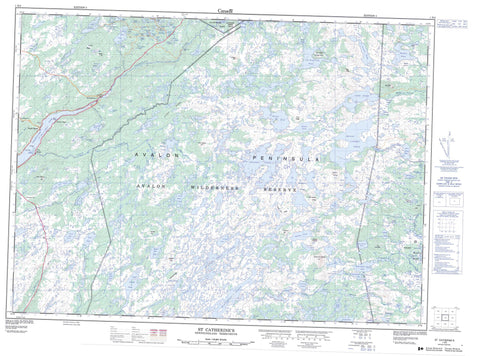
Includes UTM and GPS geographic coordinates (latitude and longitude). This 50k scale map is suitable for hiking, camping, and exploring, or you could frame it as a wall map.
Printed on-demand using high resolution, on heavy weight and acid free paper, or as an upgrade on a variety of synthetic materials.
Topos available on paper, Waterproof, Poly, or Tyvek. Usually shipping rolled, unless combined with other folded maps in one order.
- Product Number: NRCAN-001N03
- Parent Topo: TOPO-001N
- Map ID also known as: 001N03, 01N3, 1N3, 01N03, 1N03
- Unfolded Size: Approximately 26" high by 36" wide
- Weight (paper map): ca. 55 grams
- Map Type: POD NRCAN Topographic Map
- Map Scale: 1:50,000
- Geographical region: Newfoundland and Labrador, Canada
Neighboring Maps:
All neighboring Canadian topo maps are available for sale online at 1:50,000 scale.
Purchase the smaller scale map covering this area: Topo-001N
Spatial coverage:
Topo map sheet 001N03 St Catherine s covers the following places:
- Little Harbour - Salmonier Arm - Dunphys Beach - Avalon Peninsula - Big Cape - Bluff Head - Cox Point - Cross Point - Kerwan Point - Pinsents Falls - Back Pond - Back River Pond - Bad Pond - Bad Pond Steadies - Beaver Pond - Beaver Pond - Berrigans Pond - Big Pond - Big Wobble Pond - Billy Briggs Pond - Birchy Pond - Blackwood Ponds - Blind Pond - Bloody Pond - Bob Condons Pond - Bottle Hill Pond - Bread and Cheese Pond - Burkes Pond - Butlers Pond - Cahills Scrape - Cape Pond - Caribou Pond - Carters Gully - Commissioners Gullies - Corrick Ponds - Cullotens Pond - Currens Pond - Dawes Pond - Dunphys Pond - East Shoe Tavern - Engine Pond - Fly Pond - Fowlers Gullies - Franks Pond - Gibbons Pond - Green Hills Pond - Gull Pond - Gull Pond - Gull Pond - Gullivers Pond - Hardings Gullies - Hares Nest Gully - Harrys Pond - Haydens Gully - Haydens Pond - Hearns Gullies - Helicopter Pond - Hell Fire Pond - Hickeys Pond - Horse Chops Pond - Island Pond - Island Pond - Jack Powers Pond - Kearneys Pond - Kearneys Pond - Kennedys Pond - King Pond - Lamb Pond - Lavender Pond - Lawlors Gully - Little Harbour Pond - Little King Pond - Long Pond - Lumber Pond - Maries Gullies - Marsh Pond - Mickey Molloys Long Pond - Middle Pond - Middle Pond - Mikes Pond - Mikes Pond - Molloys Gullies - Moose Ear Pond - Moses Pond - Mosquito Pond - Mount Carmel Pond - Mudders Pond - Mummering - Murphys Pond - Murphys Pond - Murphys Pond - Murphys Waters - New Grove - No. 1 Pond - No. 2 Pond - No. 3 Pond - No. 4 Pond - No. 5 Pond - Nolans Pond - North Gull Pond - North Hawks Nest Pond - North Shoe Tavern - Paradise Pond - Pinnacle Ponds - Plantation Ponds - Powder Horn Pond - Prisoners Pond - Quirks Ridge Pond - Ragged Hill Pond - Ragged Hill Ponds - Rainbow - Rocky Pond - Salmon Waters - Salters Pond - Sanders Gullies - Sanders Ponds - Saunders Pond - Saunders Ponds - Seven Island Pond - Slaneys Pond - Sledgy Pond - South Gull Pond - South Hawks Nest Pond - South West Pond - Spruce Gully - Stoney River Long Pond - Stony Ridge Pond - Summit Pond - The Drop Long Pond - Three Rivers - Three Rivers Pond - Tilleys Gullies - Timblers Pond - Travellers Pond - Two Arm Pond - Wades Gully - Warrens Waters - West Shoe Tavern - Whalens Pond - Winkers Pond - Wobble Pond - Bottle Hill - Bread and Cheese Hill - Bucket Hill - Chisel Hill - Dead Fox Ridge - Drop Ridge - Eastern Lookout - Gibbons Hill - Glazy Rocks - Green Hills - Hawke Drop - High Rock - Little Harbour Hill - Little Harbour Hill - McKays Lookout - Mike Nolans Ridge - Molloys Ridge - Mount Carmel - Mount Misery - Mummerine - Peter Swains Ridge - Quirks Ridge - Ragged Hill - Stony Ridge - The Drop - The Pinnacle - The Tongue of Long Pond - Avalon Wilderness Reserve - Salmonier Nature Park - Aquaforte River - Back River - Back River - Black River - Cape Broyle River - Crossing Place River - Drooks River - Gulch Brook - Hay Ponds River - Horse Chops River - Kearneys River - La Manche River - Little Harbour River - Mitchells Brook - Mosquito Brook - Murphys River - Mussel Pond River - North River - Rattling Brook - Riverhead River - Salmonier River - Six Mile River - Southern River - Mount Carmel-Mitchells Brook-St. Catherines - Mount Carmel-Mitchells Brook-St. Catherine's - St. Joseph's - Forest Field - Forest Field-New Bridge - Mount Carmel - New Bridge - St. Catherine's - Darbys Marsh - Harricott Marsh - Mummerine Marshes


