
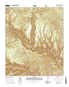
~ Woodland Park NM topo map, 1:24000 scale, 7.5 X 7.5 Minute, 2017
Woodland Park, New Mexico, USGS topographic map dated 2017.
Includes geographic coordinates (latitude and longitude). This topographic map is suitable for hiking, camping, and exploring, or framing it as a wall map.
Printed on-demand using high resolution imagery, on heavy weight and acid free paper, or alternatively on a variety of synthetic materials.
Topos available on paper, Waterproof, Poly, or Tyvek. Usually shipping rolled, unless combined with other folded maps in one order.
- Product Number: USGS-8660718
- Free digital map download (high-resolution, GeoPDF): Woodland Park, New Mexico (file size: 35 MB)
- Map Size: please refer to the dimensions of the GeoPDF map above
- Weight (paper map): ca. 55 grams
- Map Type: POD USGS Topographic Map
- Map Series: US Topo
- Map Verison: Current
- Cell ID: 49773
- Datum: North American Datum of 1983
- Map Projection: Transverse Mercator
- Map Cell Name: Woodland Park
- Grid size: 7.5 X 7.5 Minute
- Date on map: 2017
- Map Scale: 1:24000
- Geographical region: New Mexico, United States
Neighboring Maps:
All neighboring USGS topo maps are available for sale online at a variety of scales.
Spatial coverage:
Topo map Woodland Park, New Mexico, covers the geographical area associated the following places:
- Prior Creek - Big Bear Canyon - House Log Canyon - Grave Tank - Coffee Pot Tank - Woodland Park Trail - Wild Tank - Woodland Park Tank - Brothers West Tank - Prior Cabin - Yellow Bear Tank - Gila National Forest - Arrowhead Tank - Indian Creek - Green Fly Tank Number One - The Meadows - Little Bear Tank - Little Bear Canyon - Jordan Canyon - Brothers West Canyon - Nat Straw Canyon - Ring Canyon - Indian Creek Canyon - Green Fly Tank Number 2 - Jordan Mesa Tank - Ramon Tank - Middle Fork Tank - Sam Martin Spring - Grave Canyon - East Water Canyon - Green Fly Trail - Pino Tank - Marceleno Tank - Rock Tank - Green Fly Tanks - Basin Tank - Yellow Mountain - Dirt Tank Number 2 - Deep Tank - Dirt Tank - Big Bear Tank - Cassidy Spring - Adobe Tank - Woodland Park - Chicken Coop Canyon
- Map Area ID: AREA33.37533.25-108.375-108.25
- Northwest corner Lat/Long code: USGSNW33.375-108.375
- Northeast corner Lat/Long code: USGSNE33.375-108.25
- Southwest corner Lat/Long code: USGSSW33.25-108.375
- Southeast corner Lat/Long code: USGSSE33.25-108.25
- Northern map edge Latitude: 33.375
- Southern map edge Latitude: 33.25
- Western map edge Longitude: -108.375
- Eastern map edge Longitude: -108.25


