
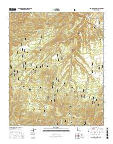
~ Sign Camp Mountain NM topo map, 1:24000 scale, 7.5 X 7.5 Minute, 2017
Sign Camp Mountain, New Mexico, USGS topographic map dated 2017.
Includes geographic coordinates (latitude and longitude). This topographic map is suitable for hiking, camping, and exploring, or framing it as a wall map.
Printed on-demand using high resolution imagery, on heavy weight and acid free paper, or alternatively on a variety of synthetic materials.
Topos available on paper, Waterproof, Poly, or Tyvek. Usually shipping rolled, unless combined with other folded maps in one order.
- Product Number: USGS-8660704
- Free digital map download (high-resolution, GeoPDF): Sign Camp Mountain, New Mexico (file size: 32 MB)
- Map Size: please refer to the dimensions of the GeoPDF map above
- Weight (paper map): ca. 55 grams
- Map Type: POD USGS Topographic Map
- Map Series: US Topo
- Map Verison: Current
- Cell ID: 41299
- Datum: North American Datum of 1983
- Map Projection: Transverse Mercator
- Map Cell Name: Sign Camp Mountain
- Grid size: 7.5 X 7.5 Minute
- Date on map: 2017
- Map Scale: 1:24000
- Geographical region: New Mexico, United States
Neighboring Maps:
All neighboring USGS topo maps are available for sale online at a variety of scales.
Spatial coverage:
Topo map Sign Camp Mountain, New Mexico, covers the geographical area associated the following places:
- Rainy Mesa Divide - Indian Tank - West Sign Camp Canyon - South Fork Negrito Creek - Deep Creek Divide - Pistol Canyon - Sign Camp Mountain - Mogollon Divide - Reserve Division - Burro Tank - Cowboy Tank - Apache Peak Trail - Twin Peaks Tank - Russ Mountain - Sheep Basin - Rainy Mesa Canyon - Burro Canyon - West Sign Camp Tank - Russ Tank - Russ Canyon - Sign Camp Canyon - Cicnega Spring - Shotgun Canyon - Old Cabin Spring - Naranjo Canyon - Christmas Tree Tank - Snow Tank - Potato Patch Canyon - Six-shooter Tank - Lower Sheep Basin Tank - Blackdeer Ridge - Chimney Canyon Tank - Upper Devils Tank - Long Mesa Tank - Sign Camp Ridge - North Fork Negrito Creek - Bear Tank - Grayback Tank - Bull Basin Canyon - Sheep Basin Tank - Sheep Basin Divide - Crossing Tank - Kiehne Ranch - Olla Tank - Six-shooter Saddle - Granny Canyon - Bull Basin Tank - Red Bull Canyon - Rainy Mesa Airstrip (historical) - Turkey Tank - Sign Camp - Cienega Tank - Oak Spring - Rainy Mesa - Cougar Tank
- Map Area ID: AREA33.62533.5-108.75-108.625
- Northwest corner Lat/Long code: USGSNW33.625-108.75
- Northeast corner Lat/Long code: USGSNE33.625-108.625
- Southwest corner Lat/Long code: USGSSW33.5-108.75
- Southeast corner Lat/Long code: USGSSE33.5-108.625
- Northern map edge Latitude: 33.625
- Southern map edge Latitude: 33.5
- Western map edge Longitude: -108.75
- Eastern map edge Longitude: -108.625


