
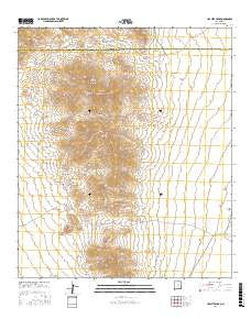
~ Hachita Peak NM topo map, 1:24000 scale, 7.5 X 7.5 Minute, 2017
Hachita Peak, New Mexico, USGS topographic map dated 2017.
Includes geographic coordinates (latitude and longitude). This topographic map is suitable for hiking, camping, and exploring, or framing it as a wall map.
Printed on-demand using high resolution imagery, on heavy weight and acid free paper, or alternatively on a variety of synthetic materials.
Topos available on paper, Waterproof, Poly, or Tyvek. Usually shipping rolled, unless combined with other folded maps in one order.
- Product Number: USGS-8639660
- Free digital map download (high-resolution, GeoPDF): Hachita Peak, New Mexico (file size: 27 MB)
- Map Size: please refer to the dimensions of the GeoPDF map above
- Weight (paper map): ca. 55 grams
- Map Type: POD USGS Topographic Map
- Map Series: US Topo
- Map Verison: Current
- Cell ID: 18831
- Datum: North American Datum of 1983
- Map Projection: Transverse Mercator
- Map Cell Name: Hachita Peak
- Grid size: 7.5 X 7.5 Minute
- Date on map: 2017
- Map Scale: 1:24000
- Geographical region: New Mexico, United States
Neighboring Maps:
All neighboring USGS topo maps are available for sale online at a variety of scales.
Spatial coverage:
Topo map Hachita Peak, New Mexico, covers the geographical area associated the following places:
- Hachita Peak - Corbett Ranch - Twelvemile Wells - Livermore Spring - Sylvanite - Faria Workings - Kinickerbocker - Broken Jug Pass - Sylvanite Mine - King Solomon - Cottonwood Spring - Gold Hill Mine - C Ranch Water Well - Copper Dick Mine - Hall Ranch - Little Hatchet Mountains - Handcar Vein - Jowell Workings - Stone Cabin Gulch - Ridgewood - Golden Eagle Mine - Lalacha Peak - Gold Hill Water Well - Howells Wells - Creeper Tunnels - Clemmie - Faith - Silver Trail Tunnel - Little Hatchet Mine - George Winkler Ranch - Green Mine - Sylvanite Post Office (historical) - Granite Pass
- Map Area ID: AREA31.87531.75-108.5-108.375
- Northwest corner Lat/Long code: USGSNW31.875-108.5
- Northeast corner Lat/Long code: USGSNE31.875-108.375
- Southwest corner Lat/Long code: USGSSW31.75-108.5
- Southeast corner Lat/Long code: USGSSE31.75-108.375
- Northern map edge Latitude: 31.875
- Southern map edge Latitude: 31.75
- Western map edge Longitude: -108.5
- Eastern map edge Longitude: -108.375


