
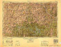
~ Jefferson City MO topo map, 1:250000 scale, 1 X 2 Degree, Historical, 1947, updated 1949
Jefferson City, Missouri, USGS topographic map dated 1947.
Includes geographic coordinates (latitude and longitude). This topographic map is suitable for hiking, camping, and exploring, or framing it as a wall map.
Printed on-demand using high resolution imagery, on heavy weight and acid free paper, or alternatively on a variety of synthetic materials.
Topos available on paper, Waterproof, Poly, or Tyvek. Usually shipping rolled, unless combined with other folded maps in one order.
- Product Number: USGS-8618496
- Free digital map download (high-resolution, GeoPDF): Jefferson City, Missouri (file size: 12 MB)
- Map Size: please refer to the dimensions of the GeoPDF map above
- Weight (paper map): ca. 55 grams
- Map Type: POD USGS Topographic Map
- Map Series: HTMC
- Map Verison: Historical
- Cell ID: 68843
- Scan ID: 707416
- Imprint Year: 1949
- Woodland Tint: Yes
- Aerial Photo Year: 1944
- Datum: NAD27
- Map Projection: Transverse Mercator
- Shaded Relief map: Yes
- Map published by United States Army Corps of Engineers
- Map published by United States Army
- Map Language: English
- Scanner Resolution: 508 dpi
- Map Cell Name: Jefferson City
- Grid size: 1 X 2 Degree
- Date on map: 1947
- Map Scale: 1:250000
- Geographical region: Missouri, United States
Neighboring Maps:
All neighboring USGS topo maps are available for sale online at a variety of scales.
Spatial coverage:
Topo map Jefferson City, Missouri, covers the geographical area associated the following places:
- Valley View - Columbia - Knobby - Hartwell - Renfro - Palo Pinto - Ohio - Gaines - Windsor Junction - Cape Galena (historical) - Payne Ford - Deer Park - Lowry City - North Jefferson - Burlington (historical) - Bannister Ford - Big Bend Acres - Lake Ozark - Holden - Sunrise Beach - McGirk - Edwards - Taberville - Henrietta - Folsom - Plummer - Clifton City - Emma - Nelson - Jordan - Faith - Brumley - Bacon - Macks Camp - Montserrat - Windsor - Valley City - Knob Noster - Lone Elm - West Aurora - Aurora Springs - Lisletown (historical) - Lake Creek - New Bloomfield - Bellair - Petersburg (historical) - Ellerslie (historical) - La Due - Millersburg - Earl - Hoffman - Big Bend - Fristoe - Petersburg - Iberia - Marshall Junction - Laurie - Hickory Hill - Finey - Providence - Damsel - Kaiser - Osage Bluff - Boylers Mill - Stokley - Cedron - Jefferson City - Lakeland - Marion - Cornelia - Oldham - Majorville - Tightwad - Zora - Brinktown - Englewood - Tackner - Proctor - Watkins - Columbus - Pleasant Green - Norris - Newland - Centertown - Pertle Springs - Lindbergh - Eugene - Summerville (historical) - Leesville - Green Bay Terrace - Wisdom - Lively - Easley - Corioli (historical) - Leeton - Lake Lafayette - Odessa - Bass - Avery - Manila
- Map Area ID: AREA3938-94-92
- Northwest corner Lat/Long code: USGSNW39-94
- Northeast corner Lat/Long code: USGSNE39-92
- Southwest corner Lat/Long code: USGSSW38-94
- Southeast corner Lat/Long code: USGSSE38-92
- Northern map edge Latitude: 39
- Southern map edge Latitude: 38
- Western map edge Longitude: -94
- Eastern map edge Longitude: -92


