
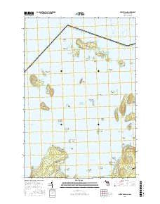
~ Burnt Island MI topo map, 1:24000 scale, 7.5 X 7.5 Minute, Current, 2016
Burnt Island, Michigan, USGS topographic map dated 2016.
Includes geographic coordinates (latitude and longitude). This topographic map is suitable for hiking, camping, and exploring, or framing it as a wall map.
Printed on-demand using high resolution imagery, on heavy weight and acid free paper, or alternatively on a variety of synthetic materials.
Topos available on paper, Waterproof, Poly, or Tyvek. Usually shipping rolled, unless combined with other folded maps in one order.
- Product Number: USGS-8594883
- Free digital map download (high-resolution, GeoPDF): Burnt Island, Michigan (file size: 18 MB)
- Map Size: please refer to the dimensions of the GeoPDF map above
- Weight (paper map): ca. 55 grams
- Map Type: POD USGS Topographic Map
- Map Series: US Topo
- Map Verison: Current
- Cell ID: 6349
- Datum: North American Datum of 1983
- Map Projection: Transverse Mercator
- Map Cell Name: Burnt Island
- Grid size: 7.5 X 7.5 Minute
- Date on map: 2016
- Map Scale: 1:24000
- Geographical region: Michigan, United States
Neighboring Maps:
All neighboring USGS topo maps are available for sale online at a variety of scales.
Spatial coverage:
Topo map Burnt Island, Michigan, covers the geographical area associated the following places:
- Little Trout Island - Dix Point - Burnt Island Reef - Burnt Island - Norris Island - Bow Island - Standerson Island - Howard Island - Butterfield Island - Harris Island - Surveyors Island - Sims Point - Mare Island - Sturgeon Point - Nate's Marina - Harbor Island Reef - Cedar Island - Twin Sister Island - Big Trout Island - Maple Island - Potagannissing Bay - Seastone Point - Homberg Point - Wilson Island - Claw Island - Spence Island - Picnic Island - Arrow Island - Fairbank Island - Black Rock Point - Rabbit Bay - Cheney Shoal - Wreck Island - Harbor Island National Wildlife Refuge - Saltonstall Island - Gull Island - Sam Island - Boulanger Island - Sturgeon Bay - Long Island - Bacon Island - Strickland Point - Stringham Lake - Cherry Island - Young Island - Harbor Island - Willoughby Island - Macomb Island - Adelaide Island
- Map Area ID: AREA46.12546-83.875-83.75
- Northwest corner Lat/Long code: USGSNW46.125-83.875
- Northeast corner Lat/Long code: USGSNE46.125-83.75
- Southwest corner Lat/Long code: USGSSW46-83.875
- Southeast corner Lat/Long code: USGSSE46-83.75
- Northern map edge Latitude: 46.125
- Southern map edge Latitude: 46
- Western map edge Longitude: -83.875
- Eastern map edge Longitude: -83.75


