
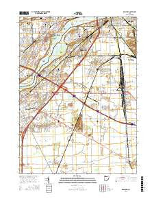
~ Rossford OH topo map, 1:24000 scale, 7.5 X 7.5 Minute, 2016
Rossford, Ohio, USGS topographic map dated 2016.
Includes geographic coordinates (latitude and longitude). This topographic map is suitable for hiking, camping, and exploring, or framing it as a wall map.
Printed on-demand using high resolution imagery, on heavy weight and acid free paper, or alternatively on a variety of synthetic materials.
Topos available on paper, Waterproof, Poly, or Tyvek. Usually shipping rolled, unless combined with other folded maps in one order.
- Product Number: USGS-8575868
- Free digital map download (high-resolution, GeoPDF): Rossford, Ohio (file size: 26 MB)
- Map Size: please refer to the dimensions of the GeoPDF map above
- Weight (paper map): ca. 55 grams
- Map Type: POD USGS Topographic Map
- Map Series: US Topo
- Map Verison: Current
- Cell ID: 38674
- Datum: North American Datum of 1983
- Map Projection: Transverse Mercator
- Map Cell Name: Rossford
- Grid size: 7.5 X 7.5 Minute
- Date on map: 2016
- Map Scale: 1:24000
- Geographical region: Ohio, United States
Neighboring Maps:
All neighboring USGS topo maps are available for sale online at a variety of scales.
Spatial coverage:
Topo map Rossford, Ohio, covers the geographical area associated the following places:
- Stanley - Shawnee Trace - Belmont Farms - Prentice (historical) - Holiday Park - Country Meadows - Island View - Glenwood Addition - River View Heights - Rockwell (historical) - Moline - Friendly Village I Mobile Home Park - Ranch Gardens - Five Point Mobile Home Court - Foxborough - Rockledge Farms - Gould - Bates - Belmont Woods - Oakmont - Pheasant Run - Candyce Grove - Rossford - Friendly Village II Mobile Home Park - Arbor Hills - Glenwood - Lime City - Stony Ridge - Perry Commons - Northwood Estates Mobile Home Park - Lakemont - Frances Gardens - Bayer Trailer Court - Indian Creek - Parliament Place - Eagle Point Colony - Secor Woods - Five Points - Southwood Park - Colonial Acres - Starbright Addition - Termway Trailer Court - East Lane Mobile Manor - Grassy Creek - The Hamlet - Valley Hills - Hobart - Oak Meadows
- Map Area ID: AREA41.62541.5-83.625-83.5
- Northwest corner Lat/Long code: USGSNW41.625-83.625
- Northeast corner Lat/Long code: USGSNE41.625-83.5
- Southwest corner Lat/Long code: USGSSW41.5-83.625
- Southeast corner Lat/Long code: USGSSE41.5-83.5
- Northern map edge Latitude: 41.625
- Southern map edge Latitude: 41.5
- Western map edge Longitude: -83.625
- Eastern map edge Longitude: -83.5


