
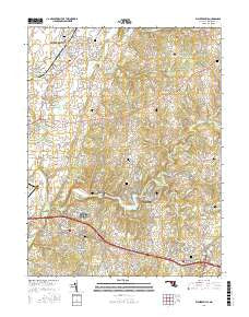
~ Walkersville MD topo map, 1:24000 scale, 7.5 X 7.5 Minute, 2016
Walkersville, Maryland, USGS topographic map dated 2016.
Includes geographic coordinates (latitude and longitude). This topographic map is suitable for hiking, camping, and exploring, or framing it as a wall map.
Printed on-demand using high resolution imagery, on heavy weight and acid free paper, or alternatively on a variety of synthetic materials.
Topos available on paper, Waterproof, Poly, or Tyvek. Usually shipping rolled, unless combined with other folded maps in one order.
- Product Number: USGS-8563944
- Free digital map download (high-resolution, GeoPDF): Walkersville, Maryland (file size: 27 MB)
- Map Size: please refer to the dimensions of the GeoPDF map above
- Weight (paper map): ca. 55 grams
- Map Type: POD USGS Topographic Map
- Map Series: US Topo
- Map Verison: Current
- Cell ID: 47277
- Datum: North American Datum of 1983
- Map Projection: Transverse Mercator
- Map Cell Name: Walkersville
- Grid size: 7.5 X 7.5 Minute
- Date on map: 2016
- Map Scale: 1:24000
- Geographical region: Maryland, United States
Neighboring Maps:
All neighboring USGS topo maps are available for sale online at a variety of scales.
Spatial coverage:
Topo map Walkersville, Maryland, covers the geographical area associated the following places:
- Spring Garden Estates - Double Tree Estates - New London - Pleasant Oaks - Thompson Estates - Eaglehead Summerfield - Sanandrews - Denneys Delight - Henleys - Boyer Mill Heights - Keyser - New Market Farms - Campers Hill - Chestnut Grove - New Market - The Greens - Ten Oaks - Mount Pleasant Estates - Martin - Pleasant Ridge - Wayne - Remsburg Heights - Peace and Plenty - Mount Pleasant - Hickory Hill - Stauffer - High Barbaree - Islands of Balmoral - Silver Hill - Harshman Estates - Nightingale - Woodridge - Honey Hill - Collmus - Elliot - Aspen - Hoot'N Hollow - Daysville Acres - Lake Anita Louise - Meadows - Woodsworth Estates - Yeager - Scouts Knoll - Sponsellers - Winter Springs - Olacin - View More Heights - Colony Village - Coldstream - North Shore - Glade Town - Whisperren Oaks - Pleasant Heights - Woodspring - Fox Pass - Reichs Ford Estates - Greenbrier - Rhod-Ayr - Ceresville - Deerfield - Mount Pleasant East - Pleasant Estates - Country Squire - Horse Shoe Farms Estates - Alpine - Pinehurst - Balmoral - Fountain Rock Manor - Discovery - Daysville - Fountain Rock - Aylor - Pine Cliff - Spring Ridge - Westwood - Darby-Lux - Viewsite Estates - Hines Woods - Bartonsville - Green Village - Walkersville - Hunting Hills - Glade Manor - McKaig - Oak Acres - New Market West - Longview - Hartman
- Map Area ID: AREA39.539.375-77.375-77.25
- Northwest corner Lat/Long code: USGSNW39.5-77.375
- Northeast corner Lat/Long code: USGSNE39.5-77.25
- Southwest corner Lat/Long code: USGSSW39.375-77.375
- Southeast corner Lat/Long code: USGSSE39.375-77.25
- Northern map edge Latitude: 39.5
- Southern map edge Latitude: 39.375
- Western map edge Longitude: -77.375
- Eastern map edge Longitude: -77.25


