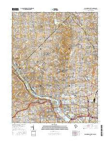
~ Washington West DC topo map, 1:24000 scale, 7.5 X 7.5 Minute, 2016
Washington West, District of Columbia, USGS topographic map dated 2016.
Includes geographic coordinates (latitude and longitude). This topographic map is suitable for hiking, camping, and exploring, or framing it as a wall map.
Printed on-demand using high resolution imagery, on heavy weight and acid free paper, or alternatively on a variety of synthetic materials.
Topos available on paper, Waterproof, Poly, or Tyvek. Usually shipping rolled, unless combined with other folded maps in one order.
- Product Number: USGS-8556335
- Free digital map download (high-resolution, GeoPDF): Washington West, District of Columbia (file size: 34 MB)
- Map Size: please refer to the dimensions of the GeoPDF map above
- Weight (paper map): ca. 55 grams
- Map Type: POD USGS Topographic Map
- Map Series: US Topo
- Map Verison: Current
- Cell ID: 47611
- Datum: North American Datum of 1983
- Map Projection: Transverse Mercator
- Map Cell Name: Washington West
- Grid size: 7.5 X 7.5 Minute
- Date on map: 2016
- Map Scale: 1:24000
- Geographical region: District of Columbia, United States
Neighboring Maps:
All neighboring USGS topo maps are available for sale online at a variety of scales.
Spatial coverage:
Topo map Washington West, District of Columbia, covers the geographical area associated the following places:
- Woodley Park - Hamburgh (historical) - Spring Hill - Shaw - Mount Vernon Square - Foggy Bottom - Senate Heights - Riverwood - Hells Bottom (historical) - Dover - Cloisters - Youngsborough (historical) - Crestwood - Kalorama Heights - Little Indian Rock Terrace - Bellevue Forest - Spring Valley - Columbia Forest - Metropolis View - Friendship Heights - North Cleveland Park - Bethesda - Brookmont - Westmoreland Terrace - Chevy Chase Heights - Brookdale - Foxhall Terrace - Edgewood - Cowtown (historical) - LeDroit Park - Brinetown (historical) - Edgewood - Woodmont - Green Acres - Tenleytown - Carroll Manor - Landon Village - Glen Cove - Scott Circle - Chevy Chase Section Three - Dunlops Hills - Westboro - Lyon Park - Brandon Village - Capitol Hill - Logan Circle - Dominion Heights - Colonial Village - Northwest Rectangle - Hawthorne - Weston (historical) - Highlands - Bradley Hills - Reno - Chevy Chase Section Five - Tunlaw Heights (historical) - Tohoga (historical) - Bloodfield (historical) - Southwest - Dupont Circle - Kenwood - Adams Morgan - Somerset Heights - Arlington - East Central - Northwest Park - The Hamlet - Bradley Woods - Huntington Terrace - Harlem (historical) - Radnor Heights - West End - Kent - Lewis Subdivision (historical) - Goodacre Knolls - Springfield - Silver Spring Park - Sligo Park Hills - English Village - Fairview Heights (historical) - Glen Mar Park - Glenbrook - Westmoreland Hills - McLean Gardens - Westgate - Foxhall - Pinehurst Circle - Kenwood Park - Huntington - Massachusetts Avenue Heights - Chevy Chase Village - Beechwood Hills - Chinatown - Whitehall Manor - Colony Hill - Rosslyn - Chevy Chase - Battery Park - Martins Addition - The Cloisters
- Map Area ID: AREA3938.875-77.125-77
- Northwest corner Lat/Long code: USGSNW39-77.125
- Northeast corner Lat/Long code: USGSNE39-77
- Southwest corner Lat/Long code: USGSSW38.875-77.125
- Southeast corner Lat/Long code: USGSSE38.875-77
- Northern map edge Latitude: 39
- Southern map edge Latitude: 38.875
- Western map edge Longitude: -77.125
- Eastern map edge Longitude: -77